North-Western Basin Branch Fleet Replenishment
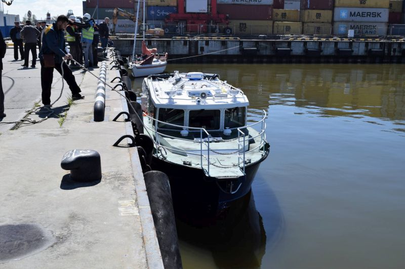
On May 19, 2017 the Meridian hydrographic boat of Project K 100 built by LLC Astron Marin (St Petersburg, Russia) was launched in the seaport of Kaliningrad under the order of the North-Western Basin Branch. The flag raising ceremony was also held aboard the vessel.
This is the ninth hydrographic vessel of the Branch and the 59th vessel within the entire fleet of the North-Western Basin Branch.
The Meridian hydrographic boat will be used by the Kaliningrad Branch for carrying out surveying operations in the water area of the seaport of Kaliningrad.
Among the advantages of this vessel there are maneuvering ability and small draft that makes it possible to carry out the shallow-water survey of the bottom configuration. In compliance with the construction of the boat it has two trunks in the hull where an echo sounder has been assembled. This makes it possible to operatively lift/launch this surveying equipment while passing to another area of the operations and also eliminates the possibility of it being damaged during the mooring.
Up-to-date electric radio navigational equipment and a multibeam echo sounder have been installed aboard the boat. They will be used to make surveys of the seabed level in the water area of the seaport of Kaliningrad.
The surveying complex installed aboard the boat includes Kongsberg EM 2040C Dual multibeam echo sounder with two acoustic antennas, the GPS/GLONASS HEMISPHERE VS-330 navigational system, DGPS corrections for determining the position of the boat accurate to 0.1 m. The complex also includes the Valeport MiniSVS sound velocity profiler and two packages of QINSy Survey hardware for gathering and processing of data of the multibeam echo sounder in online mode directly aboard the boat and QINSy Office for post-processing and office processing.
The Branch has additionally acquired and installed the Kongsberg Seatex MRU-5 motion reference unit, the so-called motion sensor that removes errors in the depth measurement in the boat's seaway and turning.
Two acoustic antennas installed on the boat will allow increasing the coverage area of inspection of bottom configuration by 2.5 times as compared with a boat having one antenna. For example, in the survey depth of 10 m the coverage area of the bottom surface by a vessel with one antenna makes up to 40 m, but when two antennas have been installed at an angle with each other, the coverage of the bottom surface make amounts to 100 m.
By using the Meridian hydrographic boat the Kaliningrad Directorate of the North-Western Basin Branch is planning to expand the possibilities and increase the effectiveness of hydrographic works carried out by the Branch in the water area of the seaport of Kaliningrad, including the works carried out on the contract base under orders of concerned organizations.
For reference:
The Meridian hydrographic boat has received its name from the term “the longitude” used in geography and astronomy that defines the surface trace line, which passes through the axis of rotation or the symmetry axis. The longitude in geography is half of the surface trade line of the Earth that has been drawn through any point of the Earth surface and the Earth rotation axis. Each longitude connects with the rest in two points: in the North Pole and the South Pole. All points of one longitude have the similar line of longitude, but the latitude is different.
The boat's principal particulars:
|
Vessel class Overall length Breadth Hull Height Draft Gross capacity Total capacity of main propulsion Speed Sea endurance Fuel capacity Crew Passenger-carrying capacity |
KM Aut3 HSC 12.55 m 3.25 m 1.68 m 0.60 m 14 GT 330 kW
30 knots 1.5 days 235 nautical miles two people up to 6 people of special personnel |