


2. VTS areas
- Arkhangelsk VTS coverage area
- Kandalaksha Gulf VTS coverage area
3. Procedure for providing navigation services with the use of VTS
- Procedure for providing navigation services with the use of the Arkhangelsk VTS
- Procedure for providing navigation services with the use of the Kandalaksha Gulf VTS
- Procedure for providing navigation services with the use of the Kola Bay VTS
- Procedure for providing navigation services with the use of the Sabetta VTS
4. Statistics
5. Contacts
The FSUE “Rosmorport” Arctic Basin Branch provides navigation services to vessels (except for small boats, pleasure boats and sports sailing ships) entering the seaports of Arkhangelsk, Kandalaksha, Murmansk and Sabetta or transiting through these seaports water areas with the use of:
– Arkhangelsk vessel traffic control system (hereinafter referred to as Arkhangelsk VTS);
– vessel traffic control system of the Kandalaksha Gulf (hereinafter referred to as Kandalaksha Gulf VTS);
– vessel traffic control system of the Kola Bay (hereinafter referred to as Kola Bay VTS);
– Sabetta vessel traffic control system (hereinafter referred to as Sabetta VTS).
Small boats, pleasure boats and sports sailing ships, located in the coverage area of Arkhangelsk VTS, Kandalaksha Gulf VTS, Kola Bay VTS and Sabetta VTS, can be provided with assistance in navigation only, upon their request and within technical limits of the VTS equipment.
The Arkhangelsk VTS includes:
– the VTS Centre (Economia);
– the automated radar post VTS site-1 (Economia);
– the automated radar post VTS site-2 (Mudyug);
– the automated radar post VTS site-3 (Talagi);
– the automated radar post VTS site-4 (NSC).
The Kandalaksha Gulf VTS includes:
– the control center located in Murmansk;
– the automated radar post located in Kandalaksha;
– the automated radar post located on Krestovaya Mountain;
The Kola Bay VTS includes:
– the control center of the Kola Bay VTS located in Murmansk;
– the Mishukovo automated radar post;
– the Krestovy automated radar post;
– the Set'-Navolok automated radar post;
– the Abram-Mys automated radar post;
– the Obzor automated radar post;
– the Ura-guba automated radar post;
– the Abram-Mys Terminal removable radar post.
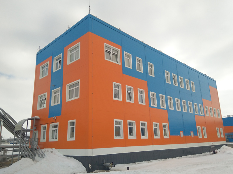
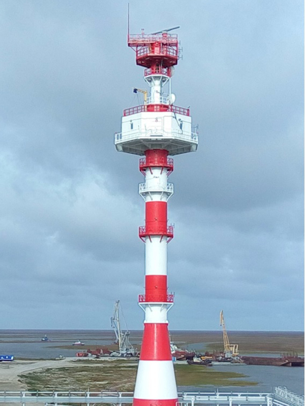
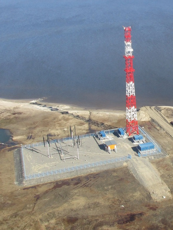
The Sabetta VTS includes:
– the control center, located in the seaport of Sabetta;
– the automated radar post VTS site-1;
– the automated radar post VTS site-2;
– the automated radar post VTS site-3.
All VTS of the Arctic Basin Branch have been created in order to increase navigation safety and navigation efficiency, the safety of life at sea, the protection of marine environment and the seacoast from pollutions, the protection of coastal facilities in the areas of relative VTS.
With the use of VTS assigned to the Arctic Basin Branch vessels are provided with all-inclusive navigation services in the areas of relative VTS and the following operations are carried out:
– to detect vessels on the approaches toward the VTS area, to establish contacts with them and to receive data about a vessel;
– to give vessels navigational, operational and other information on the initiative of VTS operators or on the request of a vessel;
– to render assistance in marine navigation;
– to organize the movement of vessels, as well as to plan and establish regimes of vessel movement in VTS coverage areas;
– to control vessel movement.
 Upon the survey conducted in accordance with the Regulations on Approval of Types of Equipment and Survey of Facilities and Centers, approved by Order of the Ministry of Transport of Russia dated 10.02.2010 No. 32, the Arctic Basin Branch received certificates from Federal Agency for Maritime and River Transportation on conformity of the Arkhangelsk VTS, the Kandalaksha Gulf VTS, the Kola Bay VTS and the Sabetta VTS with the requirements for radar vessel traffic control systems, approved by the Ministry of Transport of the Russian Federation Order dated 23.07.2015 No. 226:
- Certificate of 10.10.2025 No. 25.11.01.01610.190 on conformity of the Arkhangelsk VTS with the requirements established to the VTS of the highest category;
- Certificate of 21.06.2024 No. VTS-12/44-3322-2024 on conformity of the Kandalaksha Gulf VTS with the requirements established to the VTS of the second category;
- Certificate of 24.06.2024 No. VTS-12/44-3323-2024 on conformity of the Kola Bay VTS with the requirements established to the VTS of the highest category.
- Certificate of 22.11.2023 No. VTS-3/1-3308-2023 on conformity of the Sabetta VTS with the requirements established to the VTS of the first category.
Vessel traffic control systems used by the Arctic Basin Branch function round-the-clock.
VTS operator staff includes 59 people. All VTS operators of the Arctic Basin Branch have undergone professional training, and they are qualified in accordance with Recommendations V-103/1 of the International Association of Marine Aids to Navigation and Lighthouse Authorities.
 In accordance with the Compulsory Regulations in the Seaport of Arkhangelsk, approved by the Ministry of Transport Order No. 183 of June 9, 2014, the Arkhangelsk VTS coverage area is the Arkhangelsk seaport water area, within borders established by the Russian Government Order No. 797-r of May 19, 2010 (as amended and augmented), except for section No. 2 of the seaport water area, located in the Severnaya Bay of the Gulf of Dezhnev of Alexandra Land of Franz Josef Land.
In the Arkhangelsk VTS coverage area, reliable detection, determination of coordinates and auto tracking of vessels most typical for the area of navigation (steel vessels of 80 meters or more in length with an effective reflective surface of about 300 square meters, with visibility of 0.5 nautical miles, rainfall intensity of 60 mm/h and sea force 5) is performed, and reliable VHF radio communication with vessels and radar control are ensured. Operating area of coastal stations of the Automatic Identification System (AIS) totally covers the Arkhangelsk VTS coverage area.
Kandalaksha Gulf VTS coverage area

In accordance with the Compulsory Regulations in the seaport of Kandalaksha, approved by the Ministry of Transport of Russia order of 27.09.2024 No. 340, the boundary of the Kandalaksha Gulf VTS coverage area begins in the north from Cape Savin-Navolok, then along the coastline to Cape Smolny-Navolok, then straight to the southeast to the western end of Bolshoy Berezovy Island, then along the coastline of Bolshoy Berezovy Island to the light beacon of the forward range Krestovy (admiralty No. 5920), then straight to the southeast to Cape Tonkiy Navolok, then along the coastline to the intersection with the meridian 033°00.0' east longitude, then along an arc with a radius of 19 miles from the point of installation of the coastal radar station antenna with coordinates: latitude=67°07.6'N longitude=032°27.1'E, southwest to the intersection with the meridian 032°43.0' east longitude, then straight to the northwest to the front light beacon with coordinates: latitude=66°59.1'N longitude=032°33.7'E of the Prodolny alignment, then along the coastline to the northwest to Cape Podnavolok, then straight to the northwest to Cape Voronishny, then along the coastline to the northwest to the intersection with the meridian 032°18.4' east longitude, then straight to the northeast to the western end of Oleniy Island, then along the coastline to the southeast to the front light beacon with coordinates: latitude=67°04.7'N longitude=032°24.0'E of the Oleniy Yuzhny alignment, then straight southeast to the northwestern end of Ryashkov Island, then along the coastline of the western shore to the southern end of Ryashkov Island, then straight southeast to parallel 66°55.0' north latitude, then straight north to parallel 67°00.0' north latitude, then straight northwest to the southeastern end of Anisimov Island, then along the northern coastline to the northwestern end of Anisimov Island, then straight northwest to the rear beacon of the Kandalaksha alignment (admiralty No. 5946) and then straight northeast to Cape Savin-Navolok.
Guaranteed detection and stable escort of vessels with effective reflective surface of 50 sq.m. and over are carried out in the Kandalaksha Gulf VTS coverage area, and also reliable VHF radiotelephony communication with vessels and radar assistance is provided. The work area of shore-based stations of the automatic identification system (AIS) completely covers the area of the Kandalaksha Gulf VTS.
 In accordance with the Compulsory Regulations in the Murmansk Seaport that were approved by Order of the Ministry of Transport of Russian Federation No 222 of August 12, 2014 part of the water area
of the seaport of Murmansk in Kola Bay and approaches to it, water area of the
Ura-guba are included in the Kola Bay VTS area. Kola Bay VTS area is restricted
by:
In accordance with the Compulsory Regulations in the Murmansk Seaport that were approved by Order of the Ministry of Transport of Russian Federation No 222 of August 12, 2014 part of the water area
of the seaport of Murmansk in Kola Bay and approaches to it, water area of the
Ura-guba are included in the Kola Bay VTS area. Kola Bay VTS area is restricted
by:
– the parallel of 68 degrees 58.20 minutes North from the south;
– the coastline of the parallel of 68 degrees 58.20 minutes North from the west to Belokamenny Cape, then by the direct line sequentially connecting the following points
No 1 Velikiy Cape;
No 2 The latitude equals to 69 degrees 06.76 minutes North. The longitude equals to 033 degrees 23.35 minutes East (in the area of Retinskoye Settlement);
No 3 the eastern cap of Shurinov Island;
No 4 the eastern cap of Brandvahta Island;
No 5 Setnavolok Cape;
No 6 Pogan-navolok Cape;
No 7 crossing of Longitude Line 033 degrees 19.00 minutes East with the coastline of Kola Peninsula (in the area of Medvezhiy Cape), further by Longitude Line 033 degrees 19.00 minutes East to the north to the radius line of 19 nautical miles separated from Setnavolok Light Tower, then by the line of the above-specified radius to the southeast to Longitude Line 034 degrees 05.00 minutes East, then by Longitude Line 34 degrees 05.00 minutes East to the south from the coastline of Kildin Island, then along the western cap of Kildin Island to Byk Cape, then by the direct line connecting the following points in order:
No 1 Toporkova Pakhta Cape;
No 2 Zelenetsky Cape;
No 3 Latitude is of 69 degrees 18.25 minutes North, Longitude is of 033 degrees 40.00 minutes East,
No 4 Latitude is of 69 degrees 18.08 minutes North, Longitude is of 033 degrees 36.00 minutes East,
then by the coastline to the southwest to the point with the coordinates: Latitude of 65 degrees 15.88 minutes North, Longitude of 033 degrees 32.52 minutes East, then by the direct line connecting the following points:
No 5 Samponavolok Cape;
No 6 Chirkovy Cape;
then by the coastline to Salny-Beregovoy Sign, then to the point with the coordinates:
Latitude of 69 degrees 06.43 minutes North, Longitude of 033 degrees 25.00 minutes East, then to the point with the coordinates: Latitude of 69 degrees 05.40 minutes North, Longitude of 033 degrees 22.10 minutes East, then to the point with the coordinates: Latitude of 69 degrees 04.88 minutes North, Longitude of 033 degrees 21.42 minutes East, then to the coastline to the point with the coordinates: Latitude of 69 degrees 04.60 minutes North, Longitude of 033 degrees 19.00 minutes East, then to the direct line sequentially connecting the following points:
No 7 Nikitin Cape;
No 8 Mokhnatkin Cape,
then on the coastline to the south to the parallel of 68 degrees 58.20 minutes North.
The boundary of the coverage area of the coastal facility Ura-Guba radar post VTS of the Kola Bay VTS is located from the north-eastern cape of Bear Island at the point with coordinates: latitude=69°18.50'N longitude=32°53.40'E, then to the north-east to the points with coordinates: latitude=69°20.78'N longitude=32°54.89'E, latitude=69°22.25'N longitude=32°56.28'E, latitude=69°24.45'N longitude=32059.50'E, latitude=69°26.35'N longitude=33°03.35'E, latitude=69°30.10'N longitude=33°10.40'E, latitude=69°29.24'N longitude=33°13.60'E, then to Cape Shalim-Zapadny at the point with coordinates: latitude=69°24.40'N longitude=33001.50'E, then along the coastline to the western island of Sennye Ludy at the point with coordinates: latitude=69°22.55'N longitude=32°58.60'E, then to the point with coordinates latitude=69°20.90'N longitude=32°56.80'E, then to the point with coordinates: latitude=69°18.48'E longitude=32°55.00'E, then to the cape of the north-eastern end of Bear Island at the point with coordinates: latitude=69°18.50'N longitude=32°53.40'E.
Guaranteed detection and stable escort of vessels, which have an effective echoing area of 50 square km, are provided in the Kola Bay VTS area. Reliable VHF radio communication and radar control are provided to the vessels. The coastline working area of automatic identification system (AIS) fully covers the Kola Bay VTS area.
Regarding there is no equipment and technical means in the Kola Bay VTS for organizing reliable VHF radio communication with vessels and implementing radar monitoring in the areas of the Teriberka sea terminal and the Linakhamari sea terminal of the seaport of Murmansk, communication with vessels proceeding to the corresponding sections of the waters of the specified areas of the seaport of Murmansk is not carried out on VHF communication channel 16.

The Sabetta VTS coverage area is the territory of the gulf of Ob, restricted by the coastline and direct line sequentially connecting the following points: latitude=71°18'20,00" N and longtitude=72°01'35,80" E and latitude=71°27'19,25" N and longtitude=71°56'36,85" E, then along the arc of a circle with the center at coordinates: latitude=71°17'13.22" N and longtitude=72°02'12.67" E and a radius of 10.3 nautical miles to a point with coordinates: latitude=71°19'51.00" N and longtitude=72°33'07.75" E, then along a line connecting the points with coordinates: latitude=71°13'12.55" N and longtitude=72°14'35.20" E and latitude=71°16'03.50" N and longtitude=72°05'47.00" E, then along the coastline to a point with coordinates: latitude=71°18'20.00" N and longtitude=72°01'35.80" E, including the water area of section No. 1 of the seaport of Sabetta, as well as the anchorages of the seaport of Sabetta, with the exception of the water area of the Sabetta-Yakha River, located west of the meridian 72°02'12.67"E.
Guaranteed detection and stable escort of vessels, which have an effective echoing area of 70 square m and more, are provided in the Sabetta VTS coverage area. Reliable VHF radio communication and radar control are provided to the vessels. The coastline working area of automatic identification system (AIS) fully covers the Sabetta VTS area.
3. Procedure for providing navigation services with the use of VTS
Procedure for providing navigation services with the use of the Arkhangelsk VTS
Navigation services using the Arkhangelsk VTS are provided by the Arctic Basin Branch for vessels (except for small boats, pleasure boats and sports sailing ships) in accordance with the requirements of IMO Resolution А.1158(32), General Rules of Navigation and Mooring of Vessels in the Seaports of the Russian Federation and Their Approaches approved by the Ministry of Transport order No. 395 dated 12.11.2021 and Compulsory Regulations in the Seaport of Arkhangelsk, approved by the Ministry of Transport Order No. 183 dated 09.07.2014 (hereinafter – the Compulsory Regulations).
For small boats, pleasure boats and sports sailing ships, the Arkhangelsk VTS provides assistance in navigation upon their request within its technical limits.
All ships and vessels in the Arkhangelsk VTS coverage area equipped with radio communication of the marine mobile service, regardless of their department belonging and form of property, are obliged to implement the requirements to the navigation in the Arkhangelsk VTS area.
A regulatory approval system of vessel movement is effective in the Arkhangelsk VTS coverage area in accordance with the daily schedules for the arrangement and vessels traffic in the seaport. Vessels should enter, leave or start moving in the Arkhangelsk VTS coverage area only upon receipt of an Arkhangelsk VTS operator’s permit.
Captains of vessels, proceeding to the seaport of Arkhangelsk from the sea, should establish contact with the Arkhangelsk VTS on VHF channels 16 and 14 (call sign “Arkhangelsk-Radio-17”) and receive confirmation about recognition two nautical miles before approaching the border of the water area of the seaport of Arkhangelsk.
Captains of vessels proceeding to the seaport of Arkhangelsk from inland waterways should establish contact with the Arkhangelsk VTS two kilometers before the southern border of the seaport of Arkhangelsk on VHF channels 16 and 14 (call sign “Arkhangelsk-Radio-17”) and receive confirmation about recognition.
To enter the Arkhangelsk VTS water area, vessels must report:
- type, name of the vessel;
- country of the ship's flag;
- port of destination;
- maximum draft and air draught of the vessel;
- type and amount of cargo, class of hazard if available;
- number of crew members and passengers;
- presence of technical faults and other limitations which influence navigation safety.
The Archangelsk VTS is entitled to ask a vessel for additional data and information in accordance with the General Rules for Vessel Navigation and Mooring in Russia’s Seaports and on the Approaches Toward Them.
When an identified vessel enters the Arkhangelsk VTS coverage area, the Arkhangelsk VTS informs the vessel about the place where the pilot is accepted, the situation on the route, and transmits other information. In particular, in accordance with the Compulsory Regulations in the seaport of Arkhangelsk vessels proceeding to the seaport water areas from “Mudyugsky No. 1” light buoy to the Talagi oil base or towards the Arkhangelsk seaport water area southern border and backwards inform the Arkhangelsk VTS on their time of passage of the following control points of the seaport of Arkhangelsk:
- “Mudyugsky No. 1” floating light;
- Mudyug towers rear range parallel (in the period of icebreaking escort of vessels);
- Lebedinsky light parallel;
- Perekhodny rear range parallel (Chizhovsky road);
- Economsky lighted buoy;
- “Arkhangelsk-radio-5” and “Arkhangelsk-radio-17” responsibility areas border crossing points;
- mouth of the Povrakulka ducts (Hydrolysis plant);
- Amosovsky and Korabelny range markers crossing points;
- Moseev island;
- Kegostrovsky buoy (only when proceeding to the Nikolsky arm or from the Nikolsky arm);
- railway and road bridges.
Vessels located in the coverage area of the Arkhangelsk VTS, in accordance with the Compulsory Regulations in the seaport of Arkhangelsk also inform the Arkhangelsk VTS:
- on approaching the mooring or anchorage place;
- on forced anchoring on or near fairway, indicating the place coordinates;
- on completion of mooring, anchoring or unanchoring.
During icebreaker escort period, vessels located in the Arkhangelsk VTS coverage area, in accordance with the Compulsory Regulations in the seaport of Arkhangelsk, additionally report:
- on the vessel being stuck in ice, indicating the place coordinates;
- on passage of ice pedestrian and vehicle crossings.
After receiving information from the vessel that the mooring has started, the Arkhangelsk VTS stops monitoring the vessel’s traffic.
Transmission of navigational, meteorological, current and other information to vessels is carried out by the Arkhangelsk VTS, under request of the vessel or the captain of the seaport of Arkhangelsk order, in cases, when there are or are planned some changes in navigational situation, upon receipt of a storm warning, which can influence the navigation safety in the Arkhangelsk VTS coverage area. Transmission of the critical information can be performed by general announcement.
The Arkhangelsk VTS provides assistance in navigation at the request of the vessel or by decision of the Arkhangelsk VTS in difficult hydrometeorological conditions in case of absence or failure of technical means on board to ensure the safe movement of the vessel. When assisting in navigation, the Arkhangelsk VTS regularly transmits to the vessel information:
• about the position of the vessel against the navigation landmark, fairway and waypoints;
• about navigational dangers near the vessel and on its route;
• about the position and movement of other vessels, as well as recommendations for the further movement of the vessel.
The Arkhangelsk VTS ensures, when providing assistance in navigation, the accuracy of target auto-tracking within the range of values indicated in the attached table.
Within the Arkhangelsk VTS coverage area, information on differential corrections of the control and correction station of the GLONASS/GPS global navigation satellite systems is transferred by means of automated information systems.
The procedure for providing assistance in navigation, including the interval for transmitting information, is agreed between the Arkhangelsk VTS and the vessel using communication means. The vessel is notified by the Arkhangelsk VTS of the start and end of assistance in navigation, confirms the receipt of information and recommendations from the Arkhangelsk VTS, and informs the Arkhangelsk VTS of the actions taken.
It is up to the captain of the vessel to choose the way to control the vessel while following the recommendations and instructions of the Arkhangelsk VTS. If it is impossible to comply with the Arkhangelsk VTS instructions, the captain of the vessel passes this information to the Arkhangelsk VTS operator using communication means and informs him of his further actions and intentions.
The vessel traffic in the coverage area of the Arkhangelsk VTS is organized considering the specifics of the seaport of Arkhangelsk on the basis of the daily schedule for the placement and movement of vessels in the seaport of Arkhangelsk and includes:
- issuing permits for the movement of vessels and the arrangement of vessels in the coverage area of the Arkhangelsk VTS;
- using compulsory vessel reports on the beginning, end of movement and passage of regulated waypoints;
- using routes and priority directions for vessel traffic;
- establishing vessel traffic intervals.
Daily schedules for the movement and arrangement of vessels are approved by the captain of the seaport of Arkhangelsk and are posted daily at 16:00 Moscow time in the information and telecommunication network Internet: http://www.mapm.ru/Port/Arkhangelsk
Vessel traffic is regulated by the Arkhangelsk VTS by issuing binding instructions to vessels regarding:
- sequence and time of the beginning of movement;
- route, interval and speed;
- the procedure for the passage of fairways and their crossings by vessels;;
- ban on further movement;
- location of anchorages and shelters.

In accordance with the Compulsory Regulations in the seaport of Arkhangelsk, compulsory escort of a vessel with the use of the Arkhangelsk VTS recommendations, as well as assistance in navigation are carried out in the seaport of Arkhangelsk water area within borders form point with coordinates 65°01,4'N 40°10,2'Е along the arc of a circle drawn with radius of 5 miles from points installation of Mudyugsky No. 1 lighted buoy to the point with coordinates 65°52,5'N 40°00,0'Е, then along the line passing through the following points:
No. 1 64°45,7'N 40°22,0'Е;
No. 2 64°45,9'N 40°26,8'Е,
then along the coastal line of the left bank of the Maimaksa river to the parallel passing through the Economsky lighted range front range marker, then along the parallel with the transition to the right bank of the Maimaksa river and then along it to the left bank of the Kuznechikha river to the parallel passing through the upper end of berth No. 17 of the oil base of NK Rosneft-Arkhanhelskneftproduct JSC with transition to the right bank of the Kuznechikha river and along its right bank to its mouth, then north along the right bank of the Maimaksa river, along the western bank of the Muravoy and Lebedin islands with the transition to the Yuzhny Cape of the Mudyugsky Island and then along the western coast of the Mudyugsky island and Golaya Koshka Cape to the southern end of the nameless spit of the Zimny shore of the Dvina Bay and along its western shore to the starting point with coordinates 65°01,4'N 40°10,2'Е.
In the rest part of the seaport of Arkhangelsk the Arkhangelsk VTS provides information and traffic organization services only with the use of the Automatic Identification System and VHF radio communication based on motion graphics and arrangement of vessels, approved by the captain of the seaport of Arkhangelsk.
A vessel that has anchored, started or completed mooring to a berth in the seaport of Arkhangelsk, started moving after unmooring or leaving the berth, should inform the Arkhangelsk VTS about it.
Permission to move when unmooring or leaving the berth should be requested by the vessel from the Arkhangelsk VTS 15 minutes before the start of movement.
The permission is canceled and should be requested again if the vessel does not start the permitted actions within 15 minutes from the moment of communication with the Arkhangelsk VTS operator.
The main means of communication between the Arkhangelsk VTS and vessels in the seaport of Arkhangelsk is radio telephone communication in the VHF band of the maritime mobile service.
Communication between the Arkhangelsk VTS and vessels in the seaport of Arkhangelsk is carried out on VHF channel 14 (channel of control, call and communication with vessels during their movement), VHF channel 69 (channel for connection with vessels when assisting in navigation), call sign “Arkhangelsk-Radio-17”.
Vessels traffic control in the seaport of Arkhangelsk water area, which is carried out by the captain of the seaport of Arkhangelsk, is performed on VHF channels 14 and 16, call sign “Arkhangelsk-Radio-5”.
A vessel leaving the Arkhangelsk VTS coverage area must inform the Arkhangelsk VTS and request permission to end the radio watch on VHF working channel 14, call sign “Arkhangelsk -Radio-17”.
| Communicant | VHF communication channels | Call sign | |
| calling channel | working channel | ||
| Vessel traffic control post of the Arkhangelsk Branch of the FSBI of “Western Arctic Seaport Administration” | 16 | 14 | Arkhangelsk-Radio-5 |
| Vessel traffic service of the FSUE “Rosmorport” Arctic Basin Branch | 16 | 14, 69 | Arkhangelsk -Radio-17 |
Maintaining of radio communications not related to safety of navigation on VHF channels 14, 16, 69 in the seaport of Arkhangelsk is not allowed.
Vessels under way, as well as lying out and at seaport berths shall maintain a continuous radio watch on VHF channels 14 and 16.
Vessels lying at the berth are prohibited:
а) to switch on vessel radio location station in the operating mode;
б) to switch off the vessel automated identification system.
During mooring operations, vessels moored with tug support shall switch to the VHF operating communication channel available on the tug, informing the Arkhangelsk VTS about it. After the end of operation, vessels shall switch to the VHF operating communication channel 14, informing the Arkhangelsk VTS about it.
Radio communications between the Arkhangelsk VTS operator and vessels must be carried out in accordance with Radio Regulations of the Marine Mobile Service and the Marine Mobile Satellite Service, approved by the Ministry of Transport of Russia order No. 486 of December 9, 2022, and the message format should, where possible, meet the IMO Resolution A.851 (20) “General Principles for Ship Reporting Systems and Ship Reporting Requirements”. For radio communications with the crews of foreign vessels, English language is used in terms of “IMO's Standard Marine Communication Phrases”.
The Arctic Basin Branch VTS services provided using the Arkhangelsk VTS in the seaport of Arkhangelsk, are charged by the navigation dues. The information about navigation dues and their collection can be found in subsection “The Arctic Basin Branch Harbour Dues and Tariffs”.
Procedure for providing navigation services with the use of the Kandalaksha Gulf VTS
The Arctic Basin Branch provides navigation services to vessels (except for small boats, pleasure boats and sports sailing ships) with the use the Kandalaksha Gulf VTS in accordance with Order of Resolution IMO A.1158(32), the General Rules for Navigation and Mooring in the seaports of the Russian Federation and approaches to them approved by Order dated 12.11.2021 No. 395 of the Ministry of Transport of the Russian Federation, Compulsory Regulations in the seaport of Kandalaksha approved by Order dated 27.09.2024 No. 340 of the Ministry of Transport of the Russian Federation and by Orders of the captain of the seaport of Kandalaksha regarding the operational functions of the Kandalaksha Gulf VTS.
For small boats, pleasure boats and sports sailing ships, Kandalaksha Gulf VTS provides assistance in navigation upon their request within its technical limits.
 Irrespective of their departmental identity and forms of property all ships and vessels equipped with radio communication of the marine mobile service in the Kandalaksha Gulf VTS coverage area must comply with the rules for vessel navigation in the Kandalaksha Gulf coverage area.
In the Kandalaksha Gulf VTS coverage area authorization-based procedure is applied for the vessels movement. Vessels can enter and leave the coverage area, as well as start moving in the Kandalaska Gulf VTS coverage area only upon receiving a permission from the Kandalaksha Gulf VTS operator.
When proceeding to the seaport of Kandalaksha, captains of vessel should establish communication with the Kandalaksha Gulf VTS upon entering the Kandalaksha Gulf VTS coverage area on 16 calling, 69 working VHF communication channels (call sign “Kandalaksha-traffic”, 74 working (backup) VHF communication channel), receive confirmation of identification and transmit the following information:
- the name and type of a vessel;
- nationality of a vessel (the flag);
- the port of destination;
- maximum load draught and air draught of a vessel;
- cargo type and transportation of dangerous cargoes;
- the number of crew and passengers on board;
- the failure of ships’ technical facilities and other restrictions having influence upon navigation safety,
and receive permission to start movement.
The Kandalaksha Gulf VTS is entitled to ask for additional data and information in accordance with the General Rules for Vessel Navigation and Mooring in Russia’s Seaports and on the Approaches Toward Them.

When a vessel enters the Kandalaksha Gulf VTS coverage area, Kandalaksha Gulf VTS identifies the vessel and points it at the route, the procedure for passing fairways and their crossings, an anchoring station and reports on a position of a pilot’s embarkation and the route situation, and transmits other information.
A vessel entering the Kandalaksha Gulf VTS coverage area must inform the Kandalaksha Gulf VTS about taking a pilot aboard, passing the traverses of the island of Bolshoy Berezovy and Maly island, and report on the pollution of the marine environment, the inconsistency in the operation or the position of aids to navigation, facilities or the phenomena that pose a threat to or hamper navigation.
After receiving information from the vessel that the mooring has started, Kandalaksha Gulf VTS stops monitoring the vessel’s traffic.
 Transmission of navigation, operational and other information is carried out Kandalaksha Gulf VTS at the request of the vessel or on the initiative of the Kandalaksha Gulf VTS in cases where changes in the navigation situation, other factors, which may affect navigation safety in the Kandalaksha Gulf VTS coverage area, are planned or are taking place. Transmission of critical information can be preceded by a general announcement.
Kandalaksha Gulf VTS provides aid to vessels at the request of a vessel or by a decision taken by Kandalaksha Gulf VTS under complex meteorological conditions with no technical equipment to ensure navigation safety on a vessel, or its failure. While rendering aid to vessel Kandalaksha Gulf VTS regularly transmits information on:
- the position of a vessel toward a navigation base, a fairway and waypoints;
- dangers to navigation near a vessel and over the entire route;
- on the position and movement of other vessels, as well as recommendations related to further movement of a vessel.
When rendering aid to vessels Kandalaksha Gulf VTS ensure radar autonomous tracking accurate to no more than:
|
• by azimuth no more than 1,2º;
• by distance no more than 30 m; • by velocity of movement no more than 2 knots. |
The procedure for providing assistance in navigation, including the communications interval, is agreed by Kandalaksha Gulf VTS and the vessel using communication means. The vessel is notified by Kandalaksha Gulf VTS about the start and end of assistance in navigation, confirms the receipt of information and recommendations from Kandalaksha Gulf VTS and informs Kandalaksha Gulf VTS about the actions being taken.
The way to control the vessel while following the recommendations and instructions of Kandalaksha Gulf VTS is chosen by the captain of the vessel. If the captain finds it impossible to comply with Kandalaksha Gulf VTS instructions, he must report to the operator of Kandalaksha Gulf VTS using the means of communication and inform him about his further actions and intentions.
The movement of vessels in the Kandalaksha Gulf VTS coverage area is organized due to the specifics of the seaport of Kandalaksha based on the 24-hour schedule of vessel handling and movement in the seaport of Kandalaksha and includes:
- issuing permits on vessel movement and its handling in the Kandalaksha Gulf VTS coverage area;
- using vessels’ reports on starting, ending and passing specified points of the route;
- using routes and priority directions of vessels’ movement;
- establishing the speed and the interval of vessels’ movement.
The 24-hour schedule of vessel movement and handling in the seaport of Kandalaksha is confirmed by the captain of the seaport of Kandalaksha and published daily on the Internet: www.mapm.ru (available starting from 16:00 Moscow time every day).
Kandalaksha Gulf VTS regulates vessels’ movement by conveying them binding instructions as follows:
- movement priority and the movement start time;
- the route, the interval and the speed of the movement;
- the procedure for passing fairways and crossing them;
- the ban on further movement;
- anchoring grounds and sheltered locations.
A vessel that has anchored, started or completed mooring to a berth in the seaport of Kandalaksha, started moving after unmooring or leaving the berth, should inform Kandalaksha Gulf VTS about it.
Permission to move when unmooring or leaving the berth should be requested by the vessel from Kandalaksha Gulf VTS no less than 15 minutes before the start of movement.
If the vessel hasn't started the permitted movement within 15 minutes from the the timeframe specified by the Kandalaksha Gulf VTS, the permission should be requested again.
The main means of communication between the Kandalaksha Gulf VTS and vessels in the seaport of Kandalaksha is radiotelephone communication in the VHF range of the maritime mobile service.
Vessels located in the Kandalaksha Gulf VTS coverage area must carry a permanent radio watch on 16 calling and 67 working VHF communication channels, while vessels located in the waters of the Vitino sea terminal of the seaport of Kandalaksha must carry a permanent radio watch on 12 working and 16 calling VHF communication channels.
A vessel leaving Kandalaksha Gulf VTS coverage area must inform Kandalaksha Gulf VTS and request permission to end the radio watch on VHF working channel 69, call sign “Kandalaksha-Traffic”.
Information on the communication channels of very high frequency using in the Kandalaksha Gulf VTS
|
Communicant |
Communication channels of VHF |
Call sign |
|
|
Emergency |
Working |
||
|
Kandalaksha Gulf VTS of the FSUE “Rosmorport” Arctic Basin Branch |
16 |
69, 74 (reserve) |
Kandalaksha-traffic |
|
Service of the captain of the seaport of Kandalaksha |
16 |
67 |
Kandalaksha-radio-5 |
|
Service of the captain of the seaport of Kandalaksha |
16 |
12 |
Vitino-1 |
Conducting radio communications not related to the safety of navigation and the regulation of vessels traffic, as well as for communication between shore correspondents on the abovementioned VHF communication channels is prohibited.
VHF communication between the Kola Bay VTS and vessels must be implemented in accordance with the Radio Regulations of the Marine Mobile Service and the Marine Mobile Satellite Service, approved by the Ministry of Transport of Russia order No. 486 of December 9, 2022. Messaging in the VTS area as far as possible should correspond with the IMO Resolution A.851(20) “General Principles for Ship Reporting Systems and Ship Reporting Requirements”. For the voice communication with a foreign vessel crew “IMO Standard Marine Communication Phrases” in English is used. It is acceptable to conduct radio communications in Russian, subject to receiving a voice confirmation in English from the captain of the vessel, with the recording of such confirmation in the database of the Kandalaksha VTS documenting system.
Navigation dues are charged for navigation services provided by the Arctic Basin Branch with the use of the Kandalaksha Gulf VTS in the seaport of Kandalaksha. The information about navigation dues and their collection can be found in subsection “The Arctic Basin Branch Harbour Dues and Tariffs”.
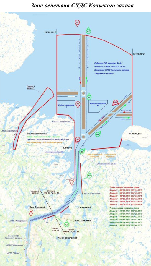
Procedure for providing navigation services with the use of the Kola Bay VTS
The Arctic Basin Branch provides navigation services to vessels (except for small boats, pleasure boats and sports sailing ships) with the use the Kola Bay VTS in accordance with the Guidance on vessel traffic services (VTS MANUAL, 2008) issued in 2008 by the International Association of Lighthouse Services, IMO А.1158(32) Resolution, Compulsory Ship Reporting System in the area of Barents Sea “Barents SRS” approved by Resolution MSC. 348(91), the General Rules for Navigation and Mooring in the seaports of the Russian Federation and approaches to them approved by Order dated 12.11.2021 No. 395 of the Ministry of Transport of the Russian Federation and Compulsory Regulations in the seaport of Murmansk approved by Order No. 222 dated 12.08.2014 of the Ministry of Transport of the Russian Federation.
For small boats, pleasure boats and sports sailing ships, Kola Bay VTS provides assistance in navigation upon their request within its technical limits.
 Irrespective of their departmental identity and forms of property all ships and vessels equipped with radio communication of the marine mobile service in the Kola Bay VTS coverage area must comply with the rules for vessel navigation in the Kola Bay VTS coverage area.
In the Kola Bay VTS coverage area authorization-based procedure is applied for the vessels movement in accordance with the daily schedules for the arrangement and vessels traffic in the seaport of Murmansk. Kola Bay VTS immediately informs the captain of the seaport of Murmansk about the movements of vessels not included in the traffic schedule and placement of vessels.
Vessel captains should establish communication with the Kola Bay VTS upon entering the seaport of Murmansk on the border of the Kola Bay VTS coverage area on 12, 16 VHF communication channels (call sign - “Murmansk-traffic”), and for vessels traveling to the water area of the seaport of Murmansk in the area of the Ura-Guba sea terminal, they should establish communication with the Kola Bay VTS on 16 VHF communication channel and, at the direction of the Kola Bay VTS, switch to the 67 VHF working communication channel (call sign - “Murmansk-traffic”), receive confirmation of identification and transmit the following information:
- the name and type of a vessel;
- nationality of a vessel (the flag);
- the port of destination;
- maximum load draught and air draught of a vessel;
- cargo type and transportation of dangerous cargoes;
- the number of crew and passengers on board;
- the failure of ships’ technical facilities and other restrictions having influence upon navigation safety.
and get permission to start movement.
The Kola Bay VTS is entitled to ask for additional data and information in accordance with the General Rules for Vessel Navigation and Mooring in Russia’s Seaports and on the Approaches Toward Them.
When a vessel enters the Kola Bay VTS coverage area, Kola Bay VTS identifies the vessel and points it at the route, the procedure for passing fairways and their crossings, an anchoring station and reports on a position of a pilot’s embarkation and the route situation, and transmits other information.
A vessel that has entered the Kola Bay VTS coverage area must report to the Kola Bay VTS when it passes the following points:
Report points for the entering vessels:
Alpha-1: 69°52,00'N 033°32,75'E
Alpha-3: 69°27,00'N 033°32,75'E
Alpha-5: 69°18,64'N 033°30,73'E
Alpha-7: 69°12,00'N 033°31,45'E
Alpha-9: 69°06,38'N 033°23,52'E
Bravo-3: 69°26,00'N 033°49'50’E
Report points for the exiting vessels:
Alpha-2: 69°45,00'N 033°35,60'E
Alpha-4: 69°29,00'N 033°35,60'E
Alpha-6: 69°17,90'N 033°32,00'E
Alpha-8: 69°11,50'N 033°32,68'E
Alpha-10: 69°04,88'N 033°19,32'E
Bravo-4: 69°23,00'N 033°46,00'E
a vessel has to report on the pollution of the marine environment, the inconsistency in the operation or the position of aids to navigation, facilities or the phenomena that pose a threat to or hamper navigation.
After receiving information from the vessel that the mooring has started, Kola Bay VTS stops monitoring the vessel’s traffic.
 Transmission of navigation, operational and other information is carried out by Kola Bay VTS at the request of the vessel or at the initiative of Kola Bay VTS in cases where changes in the navigation situation, other factors, which may affect the safety navigation in the Kola Bay VTS coverage area, are planned or are taking place. Transmission of critical information can be preceded by a general announcement.
Kola Bay VTS provides aid to vessels at the request of a vessel or by a decision taken by Kola Bay VTS under complex meteorological conditions with no technical equipment to ensure navigation safety on a vessel, or its failure. While rendering aid to vessel Kola Bay VTS regularly transmits information on:
- the position of a vessel toward a navigation base, a fairway and waypoints;
- dangers to navigation near a vessel and over the entire route;
- on the position and movement of other vessels, as well as recommendations related to further movement of a vessel.
When rendering aid to vessels Kola Bay VTS ensure radar autonomous tracking accurate to no more than:
• bearing – 0,2º;
• distance – 7 m;
• course - 0,9º;
• velocity – 0,5 knots.
In the Kola Bay VTS coverage area AIS transmits information on differential corrections of GLONASS/GPS monitoring and correcting stations.
The procedure for providing assistance in navigation, including the communications interval, is agreed by Kola Bay VTS and the vessel using communication means. The vessel is notified by Kola Bay VTS about the start and end of assistance in navigation, confirms the receipt of information and recommendations from Kola Bay VTS and informs Kola Bay VTS about the actions being taken.
The way to control the vessel while following the recommendations and instructions of Kola Bay VTS is chosen by the captain of the vessel. If the captain finds it impossible to comply with Kola Bay VTS instructions, he must report to the operator of Kola Bay VTS using the means of communication and inform him about his further actions and intentions.
The movement of vessels in the Kola Bay VTS coverage area is organized due to the specifics of the seaport of Murmansk based on the 24-hour schedule of vessel handling and movement in the seaport of Murmansk and includes:
- issuing permits on vessel movement and its handling in the Kola Bay VTS coverage area;
- using vessels’ reports on starting, ending and passing specified points of the route;
- using routes and priority directions of vessels’ movement;
- establishing the speed and the interval of vessels’ movement.
The 24-hour schedule of vessel movement and handling in the seaport of Murmansk is confirmed by the captain of the seaport of Murmansk and published daily on the Internet: www.mapm.ru (available starting from 16:00 Moscow time every day).
Kola Bay VTS regulates vessels’ movement by conveying them binding instructions as follows:
- movement priority and the movement start time;
- the route, the interval and the speed of the movement;
- the procedure for passing fairways and crossing them;
- the ban on further movement;
- anchoring grounds and sheltered locations.
A vessel that has anchored, started or completed mooring to a berth in the seaport of Murmansk, started moving after unmooring or leaving the berth, should inform Kola Bay VTS about it.
Permission to move when unmooring or leaving the berth should be requested by the vessel from Kola Bay VTS no less than 15 minutes before the start of movement.
If the vessel hasn't started the permitted movement within 15 minutes from the the timeframe specified by the Kola Bay VTS, the permission should be requested again.
Vessels located in the Kola Bay VTS coverage area must carry permanent radio watch on the 12 and 16 VHF channels.
A vessel leaving Kola Bay VTS coverage area must inform Kola Bay VTS and request permission to end the radio watch on VHF working channel 16, call sign “Murmansk-Traffic”.
Information on the communication channels very high frequency using in the Kola Bay VTS
|
Communicant |
Communication channels of VHF |
Call sign |
|
|
Emergency |
Working |
||
|
Kola Bay VTS of the FSUE “Rosmorport” Arctic Basin Branch |
16 |
12, 18, 67, 33 |
Murmansk-Traffic |
|
Inspection of the state port |
– |
14 |
Murmansk-radio-5 |
|
Inspection of the state port |
– |
37 |
Murmansk-36 |
Conducting radio communications not related to the safety of navigation and the regulation of vessels traffic, as well as communication between shore correspondents on the above VHF communication channels is prohibited.
VHF communication between the Kola Bay VTS and vessels must be implemented in accordance with the Radio Regulations of the Marine Mobile Service and the Marine Mobile Satellite Service, approved by the Ministry of Transport of Russia order No. 486 of December 9, 2022. Messaging in the VTS area as far as possible should correspond with the IMO Resolution A.851(20) “General Principles for Ship Reporting Systems and Ship Reporting Requirements”. For the voice communication with a foreign vessel crew “IMO Standard Marine Communication Phrases” in English is used.
Vessel captain must immediately inform the Kola Bay VTS operator about all the irregular situations affecting safety navigation (ship power plant breakdown, incapacitation of navigation devices or rudder propeller or ground tackle, setting down, collision, heavy weather conditions, sharp fluctuations of the water level, limited visibility etc.) both when mooring and navigating within the VTS area and hereafter execute operator’s orders.
The Arctic Basin Branch navigation services provided using the Kola Bay VTS route are charged by the navigation dues. The information about navigation dues and their collection can be found in subsection “The Arctic Basin Branch Harbour Dues and Tariffs”.
Navigation services using the Sabetta VTS are provided by the Arctic Basin Branch for vessels (except for small boats, pleasure boats and sports sailing ships) in accordance with the requirements of IMO Resolution А.1158(32), General Rules of Navigation and Mooring of Vessels in the Seaports of the Russian Federation and Their Approaches approved by the Ministry of Transport order No. 395 dated 12.11.2021, and Compulsory Regulations in the Seaport of Sabetta, approved by the Ministry of Transport Order No. 9 dated 21.01.2016 and by Orders of the captain of the seaport of Sabetta regarding the operational functions of the Sabetta VTS.
For small boats, pleasure boats and sports sailing ships, the Sabetta VTS provides assistance in navigation upon their request within its technical limits.
All ships and vessels in the Sabetta VTS coverage area equipped with radio communication of the marine mobile service, regardless of their department belonging and form of property, are obliged to implement the requirements to the navigation in the Sabetta VTS area.
A regulatory approval system of vessel movement is effective in the Sabetta VTS coverage area in accordance with the daily schedules for the arrangement and vessels traffic in the seaport. Vessels should enter, leave or start moving in the Sabetta VTS coverage area only upon receipt of an Sabetta VTS operator’s permit.
Captains of vessels, including autonomous vessels, proceeding to the seaport of Sabetta, should establish contact with the Sabetta VTS on VHF channel 14 (call sign “Sabetta-traffic”) and receive confirmation about recognition 3 nautical miles before approaching the border of the coverage area of the Sabetta VTS and should report:
- type, name of the vessel;
 - country of the ship's flag;
- port of destination;
- maximum draft and air draught of the vessel;
- type and amount of cargo, class of hazard if available;
- number of crew members and passengers;
- presence of technical faults and other limitations which influence navigation safety,
and get permission to enter/leave the Sabetta VTS coverage area.
The Sabetta VTS is entitled to ask a vessel for additional data and information in accordance with the General Rules for Vessel Navigation and Mooring in Russia’s Seaports and on the approaches to them.
When an identified vessel enters the Sabetta VTS coverage area, the Sabetta VTS informs the vessel about the place where the pilot is accepted, the situation on the route, and transmits other information.
Vessel in the Sabetta VTS coverage area has to report on the pollution of the marine environment, the inconsistency in the operation or the position of aids to navigation, facilities or the phenomena that pose a threat to or hamper navigation.
Captains of vessels, including autonomous vessels, moving within the coverage area of the Sabetta VTS, should inform the Sabetta VTS on VHF channel 14 the following information:
• on entering/leaving section No. 1 of the water area of the seaport of Sabetta;
• on passing the traverse of the pier of the south-eastern ice protection structure;
 • on anchoring a vessel, lifting a vessel from anchor;
• on the beginning of mooring;
• on the beginning and end of the vessel’s movement;
• on the embarkation/ disembarkation of a pilot;
• the vessel’s draft;
• on the expected time of the vessel’s approach to the berths and anchorages of the seaport of Sabetta, the place where the pilot will be received.
After receiving information from the vessel that the mooring has started, Sabetta VTS stops monitoring the vessel’s traffic.
Transmission of navigation, operational and other information is carried out by Sabetta VTS at the request of the vessel or by the order of the captain of the seaport of Sabetta in cases where changes in the navigation situation are planned or are taking place, or upon receiving a storm warning, which may affect the safety navigation in the Sabetta VTS coverage area. Transmission of critical information can be preceded by a general announcement.
Sabetta VTS provides aid to vessels at the request of a vessel or by a decision taken by Sabetta VTS under complex meteorological conditions with no technical equipment to ensure navigation safety on a vessel, or its failure. While rendering aid to vessel Sabetta VTS regularly transmits information:
• on the position of a vessel toward a navigation base, a fairway and waypoints;
• on dangers to navigation near a vessel and over the entire route;
• on the position and movement of other vessels, as well as recommendations related to further movement of a vessel.
When rendering aid to vessels Sabetta VTS ensure radar autonomous tracking accurate to no more than:
• by distance – no more than 10 m;
• by azimuth – no more than 0,35º;
• by course – no more than 1,5º;
• by velocity of movement – no more than 0,5 knots.
In the Sabetta VTS coverage area AIS transmits information on differential corrections of GLONASS/GPS monitoring and correcting stations.
The procedure for providing assistance in navigation, including the communications interval, is agreed by Sabetta VTS and the vessel using communication means. The vessel is notified by the Sabetta VTS about the start and end of assistance in navigation, confirms the receipt of information and recommendations from Sabetta VTS and informs Sabetta VTS about the actions being taken.
The way to control the vessel while following the recommendations and instructions of Sabetta VTS is chosen by the captain of the vessel. If the captain finds it impossible to comply with Sabetta VTS instructions, he must report to the operator of Sabetta VTS using the means of communication and inform him about his further actions and intentions.
The movement of vessels in the Sabetta VTS coverage area is organized due to the specifics of the seaport of Sabetta based on the 24-hour schedule of vessel handling and movement in the seaport of Sabetta and includes:
- issuing permits on vessel movement and its handling in the Sabetta VTS coverage area;
- using vessels’ compulsory reports on starting, ending and passing specified points of the route;
- using routes and priority directions of vessels’ movement;
- establishing the speed and the interval of vessels’ movement.
The 24-hour schedule of vessel movement and handling in the seaport of Sabetta is confirmed by the captain of the seaport of Sabetta on the basis of the information on the vessel’s call, transmitted to the captain of the seaport of Sabetta by the address in the Internet: www.portcall.marinet.ru, and published daily in the Internet: https://www.mapm.ru/Port/Sabetta .
Sabetta VTS regulates vessels’ movement by conveying them compulsory instructions as follows:
- movement priority and the movement start time;
- the route, the interval and the speed of the movement;
- the procedure for passing fairways and crossing them;
- the ban on further movement;
- anchoring grounds and sheltered locations.
The captain of the vessel operating within the Sabetta VTS coverage area must request permission from Sabetta VTS to begin movement on VHF channel 14 (call sign - "Sabetta – Traffic") after the vessel has weighed anchor or towed away from the berth in the seaport of Sabetta, 30 minutes before the expected time of movement. If the captain of a vessel, having received permission from Sabetta VTS to begin movement, fails to begin movement within 30 minutes of the expected time of movement, the master of the vessel must re-request permission from Sabetta VTS to begin movement.
The main means of communication between the Sabetta VTS and vessels in the seaport of Sabetta is radiotelephone communication in the VHF range of the maritime mobile service.
Communication between the Sabetta VTS and vessels in the seaport of Sabetta is carried out on VHF channel 14 (channel of control, call and communication with vessels during their movement) and VHF channel 67 (backup channel), call sign “Sabetta-Traffic”.
VHF radio channels and radiotelephone call sign of requesters, used to ensure the safety of navigation in the Sabetta VTS coverage area
| Communicant | VHF communication channels | Call sign | |
| calling channel | working channel | ||
| Sabetta VTS of the FSUE “Rosmorport” Arctic Basin Branch | 16 | 14, 67 | Sabetta-Traffic |
| Service of the captain of the seaport of Sabetta of the branch of the FSBI “AMP of the Western Arctic” in the seaport of Sabetta of the section No. 1 of the seaport of Sabetta water area | 16, 14 | 14 | Sabetta-Radio-5 |
| Service of the captain of the seaport of Sabetta of the branch of the FSBI “AMP of the Western Arctic” in the seaport of Sabetta of the section No. 2 of the seaport of Sabetta water area | 16, 14 | 14 | Utrenniy-Radio-5 |
| Service of the captain of the seaport of Sabetta of the branch of the FSBI “AMP of the Western Arctic” in the seaport of Sabetta of the section No. 3 of the seaport of Sabetta water area | 16, 14 | 14 | Kamenniy-Radio-5 |
Vessels located in the Sabetta VTS coverage area must carry a permanent radio watch on 14 and 16 VHF communication channels.
Vessels located on the berths of the seaport of Sabetta must carry a permanent radio watch on 14 VHF communication channel.
Radio communications on 16 VHF channel, except for calling a subscriber to switch to a working channel, are prohibited.
Radio communications not related to navigational safety and vessel traffic control, as well as communications between shore correspondents, are prohibited on the aforementioned VHF channels.
Radio communications between the Sabetta VTS operator and vessels must be carried out in accordance with Radio Regulations of the Marine Mobile Service and the Marine Mobile Satellite Service, approved by the Ministry of Transport of Russia order dated 09.12.2022 No. 486, and the message format should, where possible, meet the IMO Resolution A.851 (20) “General Principles for Ship Reporting Systems and Ship Reporting Requirements”. For radio communications with the crews of foreign vessels, English language is used in terms of “IMO's Standard Marine Communication Phrases”.
Navigation dues are charged for navigation services provided by the Arctic Basin Branch with the use of the Sabetta. The information about navigation dues and their collection can be found in “The Arctic Basin Branch Harbour Dues and Tariffs”.
Number of vessels, located in the Arkhangelsk VTS, Kandalaksha Gulf VTS, Kola Bay VTS and Sabetta VTS coverage area, that called at the corresponding seaports or transited through the waters of the seaports
Arkhangelsk VTS
| Year |
The total number of vessels located in the Arkhangelsk VTS coverage area |
Including vessels which called at/exited from the seaport of Arkhangelsk | Including vessels which transited through the waters of the seaport of Arkhangelsk |
| 2007-2022 ⇲ | |||
| 2007 | 11,535 | 2,711 | – |
| 2008 | 9,169 | 2,443 | – |
| 2009 | 7,271 | 1,983 | – |
| 2010 | 8,158 | 2,088 | – |
| 2011 | 8,157 | 2,244 | – |
| 2012 | 8,739 | 2,443 | – |
| 2013 | 9,131 | 2,313 | – |
| 2014 | 11,802 | 2,215 | – |
| 2015 | 21,008 | 2,844 | – |
| 2016 | 23,698 | 3,483 | – |
| 2017 | 22,558 | 3,581 | – |
| 2018 | 22,940 | 3,948 | – |
| 2019 | 23,840 | 4,202 | – |
| 2020 | 26,017 | 4,443 | – |
| 2021 | 26,942 | 4,778 | – |
| 2022 | 28,517 | 6,877 | – |
| 2023 | 27,939 | 5,785 |
– |
| 2024 | 28,739 | 5,180 | – |
| 2025 | 25,250 | 4,630 | – |
Kandalaksha Gulf VTS
|
Year |
The total number of vessels located |
Including vessels, which called at/exited from |
Including vessels, which transited through the Kandalaksha Gulf VTS coverage area |
| 2016-2022 ⇲ | |||
|
2016 |
363 |
66 |
– |
| 2017 | 1,706 | 118 | – |
| 2018 | 2,264 | 196 | – |
| 2019 | 2,586 | 203 | – |
| 2020 |
807 |
68 |
– |
| 2021 | 746 | 66 |
– |
| 2022 | 1,429 | 93 |
– |
| 2023 | 1,171 | 77 |
– |
| 2024 | 1,020 | 42 | – |
| 2025 | 440 | 24 | – |
Kola Bay VTS
|
Year |
The total number of vessels located |
Including vessels which called at/exited from the seaport of Murmansk |
Including vessels which transited through the Kola Bay VTS coverage area |
| 2009-2022 ⇲ | |||
|
2009 |
60,149 |
7,099 |
716 |
|
2010 |
74,044 |
7,385 |
– |
|
2011 |
93,538 |
6,641 |
– |
|
2012 |
98,229 |
6,812 |
– |
|
2013 |
88,991 |
5,991 |
– |
|
2014 |
80,261 |
5,160 |
– |
|
2015 |
75,238 |
5,041 |
– |
|
2016 |
86,396 |
5,664 |
– |
| 2017 |
94,025 |
5,856 | – |
| 2018 | 90,249 | 5,578 | – |
| 2019 | 95,399 | 5,815 | – |
| 2020 |
87,578 |
5,686 |
– |
| 2021 | 89,834 | 6,003 | – |
| 2022 | 93,122 | 5,898 |
– |
| 2023 | 100,136 | 6,477 |
– |
| 2024 | 108,139 | 6,677 | – |
| 2025 | 105,428 | 7,054 | 5,279 |
Sabetta VTS
|
Year |
The total number of vessels located in the Sabetta VTS coverage area |
Including vessels which called at the seaport of Sabetta |
Including vessels which transited through the seaport of Sabetta water area |
| 2018-2022 ⇲ | |||
| 2018 | 4,870 | 782 |
624 |
| 2019 | 6,082 | 490 | 686 |
| 2020 | 3,966 |
419 |
1,240 |
| 2021 | 4,569 | 511 | 1,750 |
| 2022 | 4,306 | 398 | 1,905 |
| 2023 | 4,229 | 429 | 1,787 |
| 2024 | 3,923 | 403 | 1,576 |
| 2025 | 3,578 | 372 | 1,166 |
Additional information on the order of the Arctic Basin Branch navigation services with the use of Arkhangelsk VTS, Kandalaksha Gulf VTS and Kola Bay VTS, can be obtained:
in the seaport of Arkhangelsk
by phone (round the clock):
+7 (8182) 67-10-18,
or by sending a request by fax: +7 (8182) 67-11-34, or by e-mail: vts@ark.rosmorport.ru
Kandalaksha Gulf VTS
by phone:
+7 (8153) 39-26-15 – Duty shift supervisor (round the clock);
+7 (921) 157-14-47 – chief of the Kandalaksha Gulf VTS (Monday – Thursday from 8:00 till 17:30, Friday from 8:00 till 15:00 by Moscow time),
or by sending a request by fax: +7 (8153) 39-26-15, or by e-mail: VTS_Kandalaksha@mrm.rosmorport.ru
Kola Bay VTS
by phone (round the clock):
+7 (8152) 47-90-26,
+7 (921) 155-00-02 – chief of the Kola Bay VTS (Monday – Thursday from 8:00 till 17:30, Friday from 8:00 till 15:00 by Moscow time),
or by sending a request by fax: +7 (8152) 47-90-26, or by e-mail: vts@mrm.rosmorport.ru
Sabetta VTS
by phone (round the clock):
+7 (921) 293-95-15,
or by sending a request by fax: +7 (8182) 65-03-43, or by e-mail: sabettaVTS@ark.rosmorport.ru


