


2. VTS coverage areas
3. VTS services terms and conditions
- Terms and conditions of navigation services with the use of Vladivostok VTS
- Terms and conditions of navigation services with the use of Nakhodka VTS
4. Statistics
5. Contacts
The Far Eastern Basin Branch of FSUE "Rosmorport" provides navigation services for vessels (except for small boats, pleasure boats and sports sailing ships) calling at the seaports of Vladivostok, Vostochny, Zarubino, Nakhodka and Posyet or transiting through their waters using the Vladivostok Vessel Traffic System (Vladivostok VTS) and Nakhodka Vessel Traffic System (Nakhodka VTS).
Small boats, pleasure boats and sports sailing ships, located in the coverage area of Vladivostok VTS and Nakhodka VTS, can be provided with assistance in navigation only, upon their request and within technical limits of the VTS equipment.
Vladivostok VTS and Nakhodka VTS meet all modern requirements and operate to improve the level of maritime safety, efficiency of navigation, safety of life at sea, including in the water areas of the seaports of Vladivostok, Vostochny, Zarubino, Nakhodka and Posyet and on the approaches to them.
Vladivostok VTS and Nakhodka VTS are used to:
• control the movement of vessels;
• transfer of navigational, meteorological, operational and other information to vessels;
• organize and regulate the vessel traffic;
• assist in navigation.
In accordance with the Mandatory Regulations in the seaport of Vladivostok, approved by the Ministry of Transport of Russia order dated 02.07.2013 No. 229, Vladivostok VTS also monitors the position of vessels at anchorages and (or) anchorage places.
The structure of Vladivostok VTS includes:
- VTS center, located on the Cape Nazimova;
- automated radar post “Elena”;
- automated radar post “Zolotoi Rog”;
- automated radar post “Bryusa”;
- automated radar post “Tumannaya”;
- automated radar post “Zarubino”;
- automated radar post “Posyet”;
- automated radar post “Goldobin”;
- automated radar post "Gorsovetskaya";
- automated radar post "ATS-51".
The structure of Nakhodka VTS includes:
- VTS center located at Cape Kamensky;
- automated radar post located at Cape Astafiev;
- automated radar post TV tower Nakhodka;
- automated radar post, located at Cape Povorotny;
- automated radar post, located at Cape Sysoev;
- automated radar post, located at Cape Krylov.
 |
Based on the results of the survey conducted in accordance with the Regulations on Approval of Types of Equipment and Survey of Facilities and Centers, approved by the Ministry of Transport of Russia order dated 10.02.2010 No. 32, the Far Eastern Basin Branch received certificates on the conformity of Vladivostok VTS and Nakhodka VTS with the requirements for radar vessel traffic control systems, approved by the Ministry of Transport of Russia order dated 23.07.2015 No. 226:
- certificate No. VTS-3/1-3288-2023 dated 14.03.2023 on the compliance of Vladivostok VTS with the requirements of IMO resolution A.857(20) and the order of the Ministry of Transport of Russia No. 226 dated 23.07.2015, applied to the highest category of VTS;
- certificate No. VTS-3/1-3289-2023 dated 14.03.2023 on the compliance of Nakhodka VTS with the requirements of the order of the Ministry of Transport of Russia No. 226 dated 23.07.2015, applied to the VTS of the highest category.
Vladivostok VTS and Nakhodka VTS operate 24 hours a day.
The operator staff of the Vladivostok VTS and Nakhodka VTS consists of 45 operators, who have undergone professional training and are certified in accordance with IALA V-103/1 Recommendations.
.JPG)
|
.JPG)
|

|
2. VTS coverage areas
In accordance with the Mandatory Regulations in the seaport of Vladivostok, approved by Order of the Ministry of Transport of Russia dated 02.07.2013 No. 229, Mandatory Regulations in the seaport of Posyet, approved by Order of the Ministry of Transport of Russia dated 19.10.2012 No. 379 and Mandatory Regulations in the seaport of Zarubino, approved by order of the Ministry of Transport of Russia dated 15.04.2013 No. 122, the coverage area of Vladivostok VTS is divided into four sectors.
Sector No. 3 includes the water area of the Vladivostok seaport, in particular the Eastern Bosphorus Strait, the Golden Horn, Diomede, Ulysses, Paris, Ajax, Patroclus bays, the north-western part of Novik Bay and adjacent areas in the Amur and Ussuri bays, and is limited by:
- in the Amur Bay – the lines connecting the cape Firsova and Peschanny, cape Perevozny and cape Vasiliev;
- in the Ussuri Bay – the lines connecting cape Tri Kamnya, a point with coordinates 43°03.00' N 132°10.00' E, a point with coordinates 42°53.00' N 131°57.00' E and cape Tobizina.
Sector No. 1A is located in the internal maritime waters and territorial sea of the Russian Federation and includes the waters of the marine terminals located in Bolshoy Kamen Bay, in the area of cape Telyakovsky and in the area of cape Otkryty of Bezzashchitnaya Bay with approaches to them in Ussuri Bay, and is bounded by:
- on the south – the boundary of the territorial sea;
- on the east – the meridian 132°28.00' E;
- on the west – lines connecting cape Klerk, points with coordinates: lat.=42°46.00' N long.=131°42.00' E, lat.=42°53.00' N long.=131°57.00' E, lat.=43°03.00' N long.=132°10.00' E and cape Tri Kamnya;
- from the north and northeast by lines connecting cape Vilkova, cape Telyakovsky, the coast of Telyakovsky Bay, cape Azaryev, the coast of Sukhodol Bay, cape Krasny, cape Maksimov, the coast of Bolshoy Kamen Bay, then by lines connecting cape Palets, cape Sedlovidny, cape Liflyandsky and cape Otkryty of Bezzashchitnaya Bay.
Sector No. 4 includes Slavyansky Bay and the southern part of Amur Bay with the adjacent part of Petra Velikogo Bay and is limited by:
- - in the Amur Bay – the line connecting cape Perevozny and cape Vasiliev;
- from the open part of the Petra Velikogo Bay - the lines connecting cape Klerka, the northern tip of Stenina island, the point with coordinates 42°44.00′ N 131°38.00′ E, the point with coordinates 42°53.00′ N 131°57.00′ E and cape Tobizina.
Sector No. 5 includes Posyet Bay and is bounded from the southeast by the line connecting cape Suslov and cape Gamov.
 |
Based on the existing composition and technical characteristics of the Vladivostok VTS equipment and on the results of its full-scale tests within the boundaries of the Vladivostok VTS coverage area established by Compulsory Regulations in the seaports of Vladivostok, Zarubino and Posyet, in the following areas navigation services are not provided using the Vladivostok VTS (there is no control over the movement of vessels and the position of vessels at anchorages, no assistance in navigation, in organizing and regulating the vessels movement in places of shelter from bad weather):
- in the water area of Bolshoi Kamen sea terminal of the seaport of Vladivostok and on the approaches to them in the Bolshoy Kamen Bay to the east from the straight line connecting cape Krasny, cape Liflyandsky and cape Otkryty of Bezzashchitnaya Bay;
- in the water area of the Telyakovsky Bay of the seaport of Vladivostok to the north from the straight line connecting Zeleny cape and Krasny cape;
- in the water area of the of the Empress Eugenie archipelago (in sectors No. 3 and No. 4), bounded by a coast line and straight lines connecting the points with coordinates:

No. 1 lat.=43°02,5' N long.=131°47,3' E;
No. 2 lat.=43°00,03' N long.=131°45,1' E;
No. 3 lat.=42°59,5' N long.=131°43,4' E;
No. 4 lat.=42°57,7' N long.=131°45,8' E;
No. 5 lat.=42°57,0' N long.=131°45,0' E;
No. 6 lat.=42°55,8' N long.=131°43,4' E;
No. 7 lat.=42°55,2' N long.=131°44,5' E;
No. 8 lat.=42°54,3' N long.=131°44,6' E;
No. 9 lat.=42°53,8' N long.=131°43,0' E;
No. 10 lat.=42°52,3' N long.=131°43,4' E;
No. 11 lat.=42°46,5' N long.=131°39,3' E;
No. 12 lat.=42°50,3' N long.=131°51,0' E;
No. 13 lat.=42°52,0' N long.=131°55,0' E;
No. 14 lat.=42°54,7' N long.=131°55,3' E;
No. 15 lat.=42°58,7' N long.=131°55,3' E;
- in the water area of the Ussuri Bay (in the sector No. 3), bounded by ta coast line and straight lines connecting the points with coordinates:
No. 1 lat.=43°04,0' N long.=131°55,4' E;
No. 2 lat.=43°04,3' N long.=131°58,0' E;
No. 3 lat.=43°06,3' N long.=132°06,6' E;
No. 4 lat.=43°09,0' N long.=132°04,0' E;
- in sector No. 1A of the Vladivostok VTS coverage area, in the area limited by the coastline and straight lines connecting in order the points with coordinates:
No. 1 lat.=42°22,8' N long.=132°28,0' E;
No. 2 lat.=42°07,4' N long.=130°54,7' E;
No. 3 lat.=42°17,7' N long.=130°42,8' E;
No. 4 lat.=42°22,0' N long.=130°45,0' E;
No. 5 lat.=42°20,5' N long.=130°47,5' E;
No. 6 lat.=42°27,4' N long.=130°54,0' E;
No. 7 lat.=42°27,0' N long.=130°55,5' E;
No. 8 lat.=42°19,0' N long.=130°50,0' E;
No. 9 lat.=42°16,3' N long.=130°58,0' E;
No. 10 lat.=42°15,5' N long.=131°05,0' E;
No. 11 lat.=42°16,0' N long.=131°11,9' E;
No. 12 lat.=42°17,5' N long.=131°18,3' E;
No. 13 lat.=42°20,3' N long.=131°24,0' E;
No. 14 lat.=42°23,4' N long.=131°28,3' E;
No. 15 lat.=42°33,3' N long.=131°13,0' E;
No. 16 lat.=42°38,5' N long.=131°15,6' E;
No. 17 lat.=42°36,9' N long.=131°19,7' E;
No. 18 lat.=42°35,8' N long.=131°25,3' E;
No. 19 lat.=42°36,0' N long.=131°31,3' E;
No. 20 lat.=42°43,0' N long.=131°30,0' E;
No. 21 lat.=42°43,0' N long.=131°31,3' E;
No. 22 lat.=42°36,1' N long.=131°33,5' E;
No. 23 lat.=42°37,8' N long.=131°39,2' E;
No. 24 lat.=42°40,7' N long.=131°44,5' E;
No. 25 lat.=42°46,6' N long.=131°49,8' E;
No. 26 lat.=42°50,8' N long.=131°51,0' E;
No. 27 lat.=42°52,0' N long.=131°54,8' E;
No. 28 lat.=42°46,0' N long.=131°55,5' E;
No. 29 lat.=42°41,5' N long.=131°58,2' E;
No. 30 lat.=42°37,4' N long.=132°02,5' E;
No. 31 lat.=42°34,8' N long.=132°07,0' E;
No. 32 lat.=42°33,2' N long.=132°13,0' E;
No. 33 lat.=42°32,5' N long.=132°17,7' E;
No. 34 lat.=42°44,8' N long.=132°18,5' E;
No. 35 lat.=42°44,0' N long.=132°22,5' E;
No. 36 lat.=42°33,5' N long.=132°27,0' E;
No. 37 lat.=42°33,8' N long.=132°28,0' E.
Guaranteed detection and sustainable support of vessels with effective reflective surface of 50 sq. m and more are provided by the Vladivostok VTS in the coverage area of the Vladivostok radar stations, and reliable radar control is also guaranteed.
The working area of the VHF radio communication with vessels and working area of the coastal stations of the Automatic Identification System (AIS) of the Vladivostok VTS completely covers the VTS operational area in the seaports of Vladivostok, Zarubino and Posyet, established by the Compulsory Regulations.
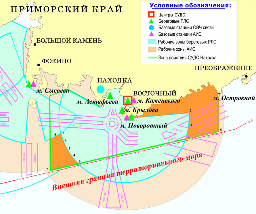
Nakhodka VTS coverage area
In accordance with the Mandatory Regulations in the seaport of Vostochny, approved by the Order of the Ministry of Transport of Russia dated 11.01.2011 No. 10, and the Mandatory Regulations in the seaport of Nakhodka, approved by the order of the Ministry of Transport of Russia dated 23.06.2011 No. 169, the VTS Nakhodka coverage area is divided into two sectors.
Sector No. 1B extends to the approaches to Nakhodka Bay and is limited by:
- from the south – the border of the territorial sea of the Russian Federation;
- from the east – the meridian 133°43,00'E;
- from the west – the meridian 132°28.00'E.
Sector No. 2 extends to the inland marine waters of Petra Velikogo Bay, includes the water area of Nakhodka Bay with the adjacent part of Petra Velikogo Bay and is limited from the south by the line connecting cape Povorotny and cape Likhacheva.

|
Based on the existing composition and technical characteristics of the Nakhodka VTS equipment and on the results of its full-scale tests within the VTS coverage area boundaries established by Compulsory Regulations in the seaports of Vostochny and Nakhodka, navigation services using the Nakhodka VTS are not provided in the following areas (there is no control over the movement of vessels and the position of vessels at anchorages, no assistance in navigation, in organizing and regulating the vessels movement in places of shelter from bad weather):
- in Nakhodka Bay;
- in Novitsky Bay;
- in Andreeva Bay;
- in Gaydamak Bay;
- in Yuzhno-Morskaya Bay;
- in Nazimova Bay;
- in Podyapolskogo Bay;
- in Five Hunters Bay;
- in Preobrazheniya Bay;
- in Moryak-Rybolov Bay;
- in the mouth of Oprichninka river;
- in the area of the Vtoroe Lake;
- in the area of the Peter the Great Gulf, bounded by straight lines connecting the points with coordinates:
№ 1 lat.=42°33,7' N long.=132°28,0' E;
№ 2 lat.=42°22,8' N long.=132°28,0' E;
№ 3 lat.=42°25,0' N long.=132°42,2' E;
№ 4 lat.=42°27,2' N long.=132°39,5' E;
№ 5 lat.=42°30,0' N long.=132°37,2' E;
№ 6 lat.=42°32,9' N long.=132°35,5' E;
№ 7 lat.=42°36,2' N long.=132°34,0' E;
№ 8 lat.=42°34,9' N long.=132°31,5' E;
- in the water area of north-western part of the Japanese Sea, bounded by the coast line and straight lines connecting the points with coordinates:
No. 1 lat.=42°40,0' N long.=133°02,0' E;
No. 2 lat.=42°42,1' N long.=133°31,4' E;
No. 3 lat.=42°38,5' N long.=133°31,3' E;
No. 4 lat.=42°34,9' N long.=133°30,2' E;
No. 5 lat.=42°36,4' N long.=133°43,2' E;
No. 6 lat.=42°48,4' N long.=133°43,2' E.
Guaranteed detection and sustainable support of vessels with effective reflective surface of 50 sq. m and more are provided by the Nakhodka VTS in the coverage area of the Nakhodka radar stations, and reliable radar control is also guaranteed.
The working area of the VHF radio communication with vessels and working area of the coastal stations of the Automatic Identification System (AIS) of the Nakhodka VTS completely covers the VTS operational area in the seaports of Vostochny and Nakhodka, established by the Compulsory Regulations.
Terms and conditions of navigation services with the use of Vladivostok VTS
Navigation services with the use of Vladivostok VTS are rendered to vessels (except for small boats, pleasure boats and sports sailing ships) in accordance with the requirements of:
- General rules for navigation and mooring of vessels in the seaports of the Russian Federation and on approaches to them, approved by Order of the Ministry of Transport of Russia No. 395 dated 12.11.2021;
- Compulsory regulations in the seaport of Vladivostok, approved by the Order of the Ministry of Transport of Russia dated No. 229 02.06.2013;
- Compulsory regulations in the seaport of Zarubino, approved by the Order of the Ministry of Transport of Russia No. 122 dated 15.04.2013;
- Compulsory regulations in the seaport of Posyet, approved by the Order of the Ministry of Transport of Russia No. 379 dated 19.10.2012;
- the orders of the captains of the seaports of Vladivostok, Zarubino or Posyet in the part relating to the operational functions of Vladivostok VTS.
For small boats, pleasure boats and sports sailing ships, Vladivostok VTS provides assistance in navigation upon their request within its technical limits.
 All ships and vessels equipped with radio communication equipment of the marine mobile service, regardless of their departmental affiliation and forms of ownership, located in the coverage area of Vladivostok VTS, must comply with the rules of navigation of vessels in the Vladivostok VTS coverage area.
In the coverage area of Vladivostok VTS a permissive procedure for vessel traffic is established. Vessels' entry/exit to the coverage area, vessel's approach to the pilot’s meeting point or the beginning of movement within the Vladivostok VTS coverage area is performed only after receiving the permission from the operator of Vladivostok VTS.
Captains of vessels bound for Vladivostok, Zarubino or Posyet seaports, when crossing the boarders of sectors No. 3, 1A, 4 and 5 of Vladivostok VTS coverage area, must establish connection with Vladivostok VTS on VHF channels 67 and 71 (Callsign - "Vladivostok-Traffic") in the appropriate sectors of VTS coverage area, get the identification confirmation and pass the following information:
- name and type of the vessel;
- nationality (flag) of the vessel;
- destination port;
- maximum effective draft and surface size of the vessel;
- type of cargo, presence of dangerous cargo;
- presence of malfunctions of vessel technical facilities and other restrictions affecting the safety of navigation,
and get permission to enter (exit) the Vladivostok VTS zone.The Vladivostok VTS has the right to request from the vessel additional information and data in accordance with the General rules for navigation and mooring of vessels in the seaports of the Russian Federation and on approaches to them.
A vessel in the Vladivostok VTS coverage area is obliged to inform about the detection of marine pollution, inconsistencies in the operation or location of navigational equipment, objects or phenomena posing a hazard or hindrance to navigation.
When an identified vessel enters the coverage area of Vladivostok VTS, Vladivostok VTS indicates its route, order of passing fairways and their crossings, anchor place, informs about the pilot’s meeting point and situation on the route, and transmits other information.After receiving information from the vessel that the mooring has started, Vladivostok VTS stops monitoring the vessel’s traffic.
The Vladivostok VTS transmits navigational, operational and other information to vessels at the request of a vessel or by order of the captains of the seaports of Vladivostok, Zarubino or Posyet, when changes in the navigational situation take place or are planned, when a storm warning is received that may affect the safety of navigation in the area covered by the Vladivostok VTS.
Navigational assistance is provided by Vladivostok VTS within the working areas of the radar stations of the Vladivostok VTS at vessel's request or by decision of Vladivostok VTS in difficult hydrometeorological conditions in the absence or malfunctioning of technical means on the vessel to ensure safe vessel movement. When providing assistance in navigation, the Vladivostok VTS regularly transmits the following information to the vessel:
.JPG)
• about the position of the vessel in relation to the navigation landmark, fairway and waypoints;
• about navigational hazards near the vessel and on its route;
• about the position and movement of other vessels, as well as recommendations for the further movement of the vessel.
When providing assistance in navigation, the Vladivostok VTS provides radar auto-tracking of targets with an error of no more than:
- bearing: ± 0,6º;
- range: 30 метров;
- at the rate: ± 2º;
- speed: ± 1,2 knots.
The procedure for providing assistance in navigation, including the communications interval, is agreed with by the Vladivostok VTS and the vessel using communication means. The vessel is notified by Vladivostok VTS about the start and the end of assistance in navigation, confirms the receipt of information and recommendations from Vladivostok VTS and informs Vladivostok VTS about the actions being taken.
The way to control the vessel while following the recommendations and instructions of Vladivostok VTS is chosen by the captain of the vessel. If the captain finds it impossible to comply with Vladivostok VTS instructions, he must report to the operator of Vladivostok VTS using the means of communication and inform him about his further actions and intentions.Organization of vessel traffic in the coverage area of Vladivostok VTS is carried out taking into account the characteristics of the seaports of Vladivostok, Zarubino and Posyet on the basis of daily schedule of deployment and movement of vessels in the relevant seaports and includes:

- issuance of permits for the movement of vessels and the placement of vessels in the area of operation of the Vladivostok VTS;
- vessel traffic planning;
- use of mandatory reports of vessels on the beginning, end of traffic and passage of regulated waypoints;
- use of routes and priority directions of vessel traffic;
- use of one-way traffic of vessels on fairways;
- setting the speed and intervals of vessels’ movement.The daily schedules of movement and placement of vessels in the seaports of Vladivostok, Zarubino and Posyet are approved by the captains of the respective seaports in accordance with the provisions of Mandatory Regulations in the seaports of Vladivostok, Zarubino and Posyet and posted on the Internet:
- the schedule of placement and movement of vessels in the seaport of Vladivostok;
- the schedule of placement and movement of vessels in the seaport of Zarubino;
- the schedule of placement and movement of vessels in the seaport of Posyet.
Vessel traffic is regulated by the Vladivostok VTS by giving binding instructions to vessel in regard to:
- priority and start time of movement;
- route, interval and speed of movement;
- the order of passage of fairways and their intersections by vessels;
- a ban on further movement;
- anchorage sites and shelters.
A vessel that has anchored, started or completed mooring to a berth in the seaports of Vladivostok, Zarubino and Posyet, started moving after unmooring or leaving the berth, should inform Vladivostok VTS about it.
Permission to move when unmooring or leaving the berth should be requested by the vessel from Vladivostok VTS at least 30 minutes before the start of movement.
If the vessel hasn’t started the permitted movement within 30 minutes from the moment specified by Vladivostok VTS, the permission should be requested again.The main means of interaction between the Vladivostok VTS and vessels is radio telephone communication in the VHF range of the maritime mobile service.
Communication of vessels with the Vladivostok VTS is carried out:
in the seaport of Vladivostok
on VHF working channel 67 (call sign "Vladivostok-Traffic") in the water area of the seaport of Vladivostok. Vessels moving or anchored in the water area of the Vladivostok seaport carry a permanent radio watch on VHF working channel 67.
Communication with vessels in sector No. 1A of Vladivostok VTS is conducted on VHF channel 71 (call sign “Vladivostok-Traffic”) or on a backup VHF channel determined by Vladivostok VTS.
A vessel transiting from sector No. 3 to sector No. 1A of the Vladivostok VTS coverage area must inform Vladivostok VTS and request permission to end radio watch on VHF channel 67 and begin radio watch on VHF channel 71.A vessel leaving Vladivostok VTS coverage area must inform Vladivostok VTS and request permission to end the radio watch on VHF working channel 67, call sign “Vladivostok-Traffic”.
in the seaport of Zarubino
on VHF channels 16 and 71 (call sign "Vladivostok-Traffic") in the water area of the seaport of Zarubino. Vessels underway must maintain a permanent radio watch on VHF channels 16 and 71. Vessels at anchorages and at the berths of the Zarubino seaport must keep constant radio watch on VHF channels 11 and 16. A tanker standing at the side of the vessel and the vessel carry a constant radio watch on the VHF channel 11.
A vessel leaving Vladivostok VTS coverage area must inform Vladivostok VTS and request permission to end the radio watch on VHF working channel 71, call sign “Vladivostok-Traffic”.
in the seaport of Posyet
on VHF working channel 71 (call sign "Vladivostok-Traffic"), in the water area of the seaport. Vessels moving or anchored in the water area of the Posiet seaport carry a constant radio watch on VHF channels 16 and 71. Vessels moored in the water area of the Posyet seaport and having no telephone communication are on constant radio watch on VHF Channel 12. Vessels moored at the Posyet seaport water areas in Slavyanka and Naezdnik bays are on constant radio watch on VHF Channel 30.
A vessel leaving Vladivostok VTS coverage area must inform Vladivostok VTS and request permission to end the radio watch on VHF working channel 71, call sign “Vladivostok-Traffic”.
VHF radio communication channels and radiotelephone callsigns of subscribers used to ensure the safety of navigation in the coverage area of Vladivostok VTS
| Subscriber | Very high frequency radio channels | Call | |
|
Call (duty) |
Working call |
||
| Vladivostok VTS of the Far Eastern Basin Branch FSUE "Rosmorport" in the seaport of Vladivostok | 16,67 | 67 | Vladivostok- Traffic |
| Vladivostok VTS of the Far Eastern Basin Branch FSUE "Rosmorport" in the seaport of Zarubino | 16,71 | 67,71 | Vladivostok- Traffic |
| Vladivostok VTS of the Far Eastern Basin Branch FSUE "Rosmorport" in the seaport of Posyet | 16 | 71 | Vladivostok- Traffic |
| State Port Control Inspectorate of the seaport of Vladivostok FGBI "AMP of Primorsky Krai and the Eastern Arctic" | 12 | 12,67 | Vladivostok- Port Control |
| Port State Control Inspectorate in the seaport of Zarubino FGBI "AMP of Primorsky Krai and Eastern Arctic" | 16 | 11 | Troitsa-33 |
| Port State Control Inspection at the seaport Posiet in the area of the seaport water area in the bay Posyet FGBI "AMP of Primorsky Krai and the Eastern Arctic" | 16 | 12 | Posyet- Port control |
| Port State Control Inspection at the seaport Posyet on the site of the water area of the seaport in the bay Slavyanka FGBI "AMP of Primorsky Krai and the Eastern Arctic" | 16 | 30 | Slavyanka-Port Control |
Conducting radio communications in the seaports of Vladivostok, Zarubino or Posyet, not related to the safety of navigation, on specified VHF channels, as well as the use of VHF channels for communication between shore correspondents, is not allowed.
Communication between Vladivostok VTS and vessels is carried out in accordance with the Rules of radio communication of marine mobile service and marine satellite mobile service, approved by the Order of the Ministry of Transport of Russia No. 486 dated 09.12.2022. For radiotelephone communication with vessels under foreign flags, English language is used, using the IMO standard phrases for marine radio communication approved by Resolution A.918(22). Transmission of messages from vessels to Vladivostok VTS and the format of messages should, if possible, comply with IMO Resolution A.851(20) "General principles of vessel reporting systems and requirements for vessel reporting".
For navigation services provided by the Far Eastern Basin Branch with the use of Vladivostok VTS, navigation dues are charged from the vessels calling at the seaports of Vladivostok, Zarubino and Posyet. Information on the rates of the navigation dues and the procedure for their collection is given in the section "Harbour dues and tariffs of the Far Eastern Basin Branch".
Terms and conditions of navigation services with the use of Nakhodka VTS
Navigation services with the use of Nakhodka VTS are rendered to vessels (except for small boats, pleasure boats and sports sailing ships) in accordance with the requirements of:
- General rules for navigation and mooring of vessels in seaports of the Russian Federation and on approaches to them, approved by Order of the Ministry of Transport of Russia No. 395 dated 12.11.2021;
- Compulsory regulations in the seaport of Vostochny seaport approved by the Order of the Ministry of Transport of Russia No. 10 dated 11.01.2011;
- Compulsory regulations in the seaport of Nakhodka, approved by Order of the Ministry of Transport of Russia No. 169 dated 23.06.2011;
- the orders of the captains of Vostochny or Nakhodka seaports in the part concerning operational functions of Nakhodka VTS.
For small boats, pleasure boats and sports sailing ships, Nakhodka VTS provides assistance in navigation upon their request within its technical limits.
All ships and vessels equipped with radio communication facilities of marine mobile service, regardless of their departmental affiliation and form of ownership, which are in the coverage area of Nakhodka VTS, must comply with the rules of navigation of vessels in the coverage area of Nakhodka VTS.
In the coverage area of Nakhodka VTS, a permissive procedure for vessel traffic is established. Vessels enter/leave the area of operation, approach the pilot reception point or begin movement within the coverage area Nakhodka VTS only after receiving permission from the operator of Nakhodka VTS.
Captains of vessels bound for Vostochny or Nakhodka seaports must establish communication with Nakhodka VTS on VHF channel 9 (call sign – ”Nakhodka-Traffic”) when crossing the Russian Federation territorial sea border (boundary of the coverage area of Nakhodka VTS), receive identification confirmation and transmit the following information:
- name and type of the vessel;
- nationality (flag) of the vessel;
- destination port;
- maximum effective draft and surface size of the vessel;
- type of cargo, presence of dangerous cargo;
- presence of malfunctions of vessel technical facilities and other restrictions affecting the safety of navigation,
and get permission to enter (exit) the Nakhodka VTS zone.
Nakhodka VTS has the right to request additional information from the vessel in accordance with the General rules for navigation and mooring of ships in seaports of the Russian Federation and on approaches to them.
A vessel in the Nakhodka VTS coverage area is obliged to inform about the detection of marine pollution, inconsistencies in the operation or location of navigational equipment, objects or phenomena that pose a hazard or hindrance to navigation.
When an identified vessel enters the Nakhodka VTS coverage area, Nakhodka VTS indicates its route, order of passing the fairways and their crossings, anchor place, informs about the pilot reception place and the situation on the route, as well as transmits other information.
After receiving information from the vessel that the mooring has started, Nakhodka VTS stops monitoring the vessel’s traffic.
Transfer of navigational, operational and other information to vessels is carried out by Nakhodka VTS at the request of a vessel or by order of captains of Vostochny or Nakhodka seaports when changes in navigational situation take place or are planned, when storm warning is received, which can affect safety of navigation in the area of Nakhodka VTS.
Assistance in navigation is provided by Nakhodka VTS within the working areas of the radar stations of the Nakhodka VTS at the request of the vessel or by decision of Nakhodka VTS in difficult hydrometeorological conditions in the absence or malfunction of technical means on the vessel to ensure safe movement of the vessel. When assisting in navigation, the Nakhodka VTS regularly transmits the following information to the vessel:
• about the position of the vessel in relation to the navigation landmark, fairway and waypoints;
• about navigational hazards in the vicinity of the vessel and on its route;
• about the position and movement of other vessels, as well as recommendations for the further movement of the vessel.
When assisting in vessel navigation, the Nakhodka VTS provides radar auto-tracking of targets with an error of no more than:
- bearing: ± 0,6º;
- range: 30 метров;
- at the rate: ± 2º;
- speed: ± 1,2 узла.
In the coverage area of Nakhodka VTS, information about the differential corrections of the control-correcting station of the global navigation satellite systems GLONASS/GPS is transmitted through the AIS.
The procedure for providing assistance in navigation, including the communications interval, is agreed by Nakhodka VTS and the vessel using communication means. The vessel is notified by Nakhodka VTS about the start and end of assistance in navigation, confirms the receipt of information and recommendations from Nakhodka VTS and informs Nakhodka VTS about the actions being taken.
The way to control the vessel while following the recommendations and instructions of Nakhodka VTS is chosen by the captain of the vessel. If the captain find it impossible to comply with Nakhodka VTS instructions, he must report the operator of Nakhodka VTS using the means of communication and inform him about his further actions and intentions.
Organization of vessel traffic in the coverage area of Nakhodka VTS is carried out taking into account the characteristics of the Vostochny and Nakhodka seaports based on the daily schedule of vessel deployment and traffic in respective seaports and includes:
- issuance of permits for vessel traffic and deployment of vessels in the Nakhodka VTS coverage area;
- vessel traffic planning;
- use of mandatory reports of vessels on the beginning, end of traffic and passage of regulated waypoints;
- use of routes and priority directions of vessel traffic;
- use of one-way traffic of vessels on fairways;
- establishment of speed and intervals of movement of vessels.
Daily schedules for movement and deployment of vessels in the seaports of Vostochny and Nakhodka are approved by the captains of the respective seaports in accordance with the provisions of the Mandatory Regulations at the seaports of Vostochny and Nakhodka and are posted on the Internet:
- schedule of placement and movement of vessels in the seaport of Vostochny;
- schedule of placement and movement of vessels in the seaport of Nakhodka.
Vessel traffic is regulated by the Nakhodka VTS by transmitting binding instructions to vessels in respect of:
- priority and start time of movement;
- route, interval and speed of movement;
- the order of passage of fairways and their intersections by vessels;
- a ban on further movement;
- anchorage sites and shelters.
A vessel that has anchored, started or completed mooring to a berth in the seaports of Vostochny or Nakhodka, started moving after unmooring or leaving the berth, should inform Nakhodka VTS about it.
Permission to move when unmooring or leaving the berth should be requested by the vessel from Nakhodka VTS at least 30 minutes before the start of movement.
If the vessel hasn’t started the permitted movement within 30 minutes from the moment specified by Nakhodka VTS, the permission should be requested again.
The main means of interaction between Nakhodka VTS and vessels is radio telephone communication in the VHF range of the maritime mobile service.
Communication of vessels with the Nakhodka VTS is carried out:
in the seaport of Vostochny
a) on VHF channel 9 (call sign "Nakhodka-Traffic") for vessels on approaches to Nakhodka Bay in sector No. 1B;
b) on VHF channel 13 (call sign "Nakhodka-Traffic") for vessels bound for Nakhodka Bay, when crossing the line cape Likhacheva - cape Povorotny;
c) on VHF channels 16 and 13 (call sign "Nakhodka-Traffic") in the water area of the Vostochny seaport (except for the water area of Lake Vtoroe).
Vessels anchored in the Vostochny seaport water area are on permanent radio watch on VHF channels 14 and 16. Vessels in Wrangel Bay and those staying at the Vostochny Seaport berths, which have no telephone service, are on permanent radio watch on VHF Channel 14 of the seaport. Vessels located at the berths of the Vostochny seaport in Kozmina Bay carry a permanent radio watch on VHF channels 14 and 29.
A vessel leaving Nakhodka VTS coverage area must inform Nakhodka VTS and request permission to end the radio watch on VHF working channel 9, call sign “Nakhodka-Traffic”.
in the seaport of Nakhodka
a) on VHF channel 9 (call sign "Nakhodka-Traffic") for vessels on approaches to Nakhodka Bay in sector No. 1B;
b) on VHF channel 13 (call sign "Nakhodka-Traffic") for vessels bound for Nakhodka Bay, when crossing the line cape Likhacheva – cape Povorotny.
c) on VHF channels 16 and 13 (call sign "Nakhodka-Traffic") in the water area of Nakhodka seaport (except Nakhodka, Novitsky, Andreeva, Gaidamak, Yuzhno-Morskaya, Nazimova, Podyapolskogo, Pyati Okhotnikov, Preobrazheniya, Moryak-Robolov bays and in the mouth of Oprichninka river).
Vessels on the move in Nakhodka seaport water area are required to keep constant radio watch on VHF channel 13.
A vessel leaving Nakhodka VTS coverage area must inform Nakhodka VTS and request permission to end the radio watch on VHF working channel 13, call sign “Nakhodka-Traffic”.
VHF radio communication channels and radio telephone callsigns of subscribers used to ensure the safety of navigation in the coverage area of Nakhodka VTS
| Subscriber | Very high frequency radio channels | Call | |
|
Call (duty) |
Working call |
||
| VTS Nakhodka of the Far East Basin branch of FSUE "Rosmorport" in the seaport of Vostochny | 16 | 13 | Nakhodka- Traffic |
| VTS Nakhodka of the Far East Basin branch of FSUE "Rosmorport" in the seaport of Nakhodka | 16 | 13,9 | Nakhodka- Traffic |
| State port control in the seaport of Vostochny of FSBI "AMP of Primorsky Krai and the Eastern Arctic" | 14 | 14 |
Vostochny-5 |
| State port control in Kozmina Bay in the seaport of Vostochny of FGBI "AMP of Primorsky Krai and the Eastern Arctic" | 14,29 | 14,29 | Kozmina-AMP Vostochny |
Conducting radio communications in the seaports of Vostochny or Nakhodka, not related to ensuring safety of navigation, on the specified VHF communication channels, as well as using VHF communication channels for communication between onshore correspondents, is not allowed.
Communication between Nakhodka VTS and vessels is carried out in accordance with the Rules of radio communication of marine mobile service and marine satellite mobile service, approved by order of the Ministry of Transport of Russia No. 486 dated 09.12.2022. For radiotelephone communication with vessels under a foreign flag, English language is used with the use of "IMO standard phrases for maritime radio communications" approved by Resolution A.918(22). Transmission of messages from vessels to Nakhodka VTS and the message format should, if possible, comply with IMO Resolution A.851(20) "General principles of vessel reporting systems and requirements for vessel reporting".
For navigation services provided by the Far Eastern Basin Branch with the use of Nakhodka VTS, navigation dues are charged from vessels calling at the Vostochny or Nakhodka seaports. Information about navigation dues rates and the procedure for charging them is given in the section "Harbour dues and tariffs of the Far Eastern Basin Branch".
Information on the number of vessels that were in the coverage areas of the Vladivostok VTS and the Nakhodka VTS that entered/departed from the seaports of Vladivostok, Vostochny, Zarubino, Nakhodka and Posyet, or transited through the coverage areas of the Vladivostok VTS and the Nakhodka VTS:
Vladivostok VTS
|
Year |
Number of vessels |
||||
|
Number of |
Including |
Including |
Including |
Including |
|
| 2012–2022 ⇲ | |||||
|
2012 |
62,952 |
7,328 |
1,213 |
1,266 |
717 |
|
2013 |
47,112 |
7,264 |
1,154 |
1,473 |
696 |
|
2014 |
45,773 |
15,703 |
2,329 |
2,777 |
672 |
|
2015 |
44,301 |
12,501 |
2,174 |
2,227 |
576 |
|
2016 |
41,332 |
12,042 |
1,601 |
2,134 |
466 |
|
2017 |
44,433 |
13,196 |
1,844 |
2,449 |
516 |
|
2018 |
52,296 |
13,773 |
2,183 |
2,788 |
858 |
| 2019 | 79,465 | 15,818 | 1,923 | 3,172 | 2,236 |
| 2020 | 84,534 | 16,592 | 1,990 | 2,878 | 746 |
| 2021 | 79,421 | 16,262 | 2,442 | 939 | 207 |
| 2022 | 86,701 | 17,506 | 2,531 | 876 | 193 |
| 2023 | 89,626 | 19,104 | 2,795 | 2,957 | 158 |
| 2024 | 85,565 | 17,766 | 2,159 | 697 | 142 |
| 2025 | 83,050 | 17,376 | 2,374 | 3,067 | 196 |
Nakhodka VTS
|
Year |
Number of vessels |
|||
|
Number of |
Including |
Including |
Including |
|
| 2012–2022 ⇲ | ||||
|
2012 |
56,004 |
2,613 |
3,739 |
612 |
|
2013 |
66,417 |
3,857 |
5,177 |
584 |
|
2014 |
79,730 |
7,588 |
12,583 |
538 |
|
2015 |
72,655 |
8,152 |
10,810 |
497 |
|
2016 |
55,289 |
7,437 |
8,533 |
372 |
|
2017 |
52,561 |
7,284 |
9,239 |
487 |
|
2018 |
62,799 |
7,160 |
8,680 |
635 |
| 2019 | 94,187 | 7,378 | 9,866 | 3,050 |
| 2020 | 86,038 | 7,040 | 8,421 | 3,321 |
| 2021 | 83,512 | 6,350 | 8,719 | 3,325 |
| 2022 | 82,532 | 5,958 | 8,106 | 3,231 |
| 2023 | 88,167 | 3,456 | 4,453 | 3,233 |
| 2024 | 85,030 | 3,315 | 4,573 | 2,963 |
| 2025 | 82,664 | 3,186 | 4,212 | 2,888 |
Additional information on the order of the FSUE “Rosmorport” Far Eastern Basin Branch navigation services with the use of RVTS of the Peter the Great Gulf, can be obtained round the clock:
in the seaports of Vladivostok, Zarubino, Posyet
by phone:
+7 (423) 249-84-00,
or by sending a request by fax: +7 (423) 249-84-33, or by e-mail: vts.vldv@dvf.rosmorport.ru.
in the seaports of Vostochny, Nahodka
by phone:
+7 (4236) 61-60-05,
or by sending a request by fax: +7 (4236) 61-60-05 or by e-mail: vts.nhdk@dvf.rosmorport.ru.


