


- Saint-Petersburg VTS coverage areas
- The Vysotsk VTS coverage area
- The Kaliningrad VTS coverage area
- The Primorsk VTS coverage area
- The Ust-Luga VTS coverage area
- Terms and conditions of navigation VTS services with the help of the Saint-Petersburg VTS
- Terms and conditions of navigation VTS services with the help of the Vysotsk VTS
- Terms and conditions of navigation VTS services with the help of the Kaliningrad VTS
- Terms and conditions of navigation VTS services with the help of Primorsk VTS
- Terms and conditions of navigation VTS services with the help of the Ust-Luga VTS
5. Contacts
1. General information
The FSUE “Rosmorport” North-West Basin Branch offers complex navigation services to vessels (except for small boats, pleasure boats and sports sailing ships) calling at the seaports of Big Port of Saint Petersburg, Vyborg, Vysotsk, Kaliningrad, Passenger Port of Saint Petersburg, Primorsk, and Ust-Luga or passing their water areas by transit, including but not limited to the direction of the Saimaan canal, and also to vessels located within the territorial waters of the Russian Federation in the eastern part of the Gulf of Finland. Navigation services are rendered with the help of the Regional Vessel Traffic Service of the Eastern Part of the Gulf of Finland (further referred to as RVTS) and Port Vessel Traffic Service of Kaliningrad (further referred to as the Kaliningrad VTS), secured to the branch.
Small boats, pleasure boats and sports sailing ships, located in the coverage area of Kaliningrad VTS, can be provided with assistance in navigation only, upon their request and within technical limits of the VTS equipment.
RVTS was created and operates on the basis on informational integration and coordinated activities of the following vessels traffic services:
- Saint Petersburg VTS;
- port VTS of the seaport of Vysotsk (further referred to as Vysotsk VTS);
- port VTS of the seaport of Primorsk (further referred to as Primorsk VTS);
- port VTS of the seaport of Ust-Luga (further referred to as Ust-Luga VTS).
Saint Petersburg VTS consists of:
- VTS Center (Peterhof);
- VTS subcenter (Saint Petersburg);
- Raskat RTP;
- Golova Nevskykh Vorot ((Head of the Nevsky Gate) RTP;
- 41 Prichal (Berth 41) RTP;
- Zadny stvorny znak (Rear range marker) RTP;
- Strelna RTP;
- Bronka RTP;
- Kotlin RTP;
- Karavaldai RTP;
- Seskar RTP;
- Sommers RTP;
- Gogland RTP.
Vysotsk VTS consists of:
- VTS Center (seaport of Vysotsk);
- RTP (seaport of Vysotsk);
- Bobrovy RTP.
Primorsk VTS consists of:
- VTS Center (port of Primorsk);
- Primorsk RTP;
- Vyazy RTP.
Ust-Luga VTS consists of:
- VTS Center (Gorki village);
- Gorki RTP;
- Koskolovo RTP;
- Port RTP.
Kaliningrad VTS consists of:
- VTS Center (Baltiysk);
- ARTP No. 1 (Baltic Spit);
- ARTP No. 2 (Izhevsky turn of the Kaliningrad Marine Canal);
- ARTP No. 3 (Rybachy point);
- ARTP No. 4 (Sinyavino village).
RVTS and the Kaliningrad VTS were created for the purpose of increasing navigation safety and navigation efficiency, safety of life at sea, protection of sea and coastal environment from pollution, protection of te coastal structures in the coverage areas of the certain vessel traffic services.
Saint Petersburg VTS center enables operation of the Russian part of Gulf of Finland Reporting system (GOFREP) organized according to Memorandum on mutual understanding between the ministries of transport of the Republic of Estonia, the Republic of Finland, and Russian Federation on further strengthening of cooperation aiming at increasing navigation safety in the Gulf of Finland.
The following navigation services are rendered with the help of the VTS secured to the North-West Basin:
- locating vessels in the approaches to the VTS coverage areas, establishing connections with them, receiving information on the vessels;
- transmission to vessels of navigation, current, and other information upon the initiative of the VTS operators, or by request of the vessels;
- navigation assistance;
- navigation arrangement, including planning and establishing of the vessel traffic schedules in the VTS coverage areas in the seaport of Big Port of Saint-Petersburg, Vyborg, Vysotsk, Kaliningrad, Passenger Port of Saint Petersburg, Primorsk, and Ust-Luga;
- control over navigation.
Upon the survey conducted in accordance with the Regulations on Approval of Types of Equipment and Survey of Facilities and Centers, approved by Order of the Ministry of Transport of Russia dated 10.02.2010 No. 32, the North-West Basin Branch received certificates on compliance of the VTS secured to it to the technical and operational requirements approved by the Ministry of Transport of the Russian Federation Order No. 226 of 23.07.2015 and IMO А.1158(32) Resolution:
- certificate on compliance of the Saint Petersburg VTS to the requirements of high-grade category VTS VTS-3/1-3243-2021 of December 27, 2021;
- certificate on compliance of the Vysotsk VTS to the requirements of first grade category VTS No. VTS-12/44-3320-2024 of June 20, 2024;
- certificate on compliance of the Kaliningrad VTS to the requirements of high-grade category VTS No. VTS-3/1-3266-2022 of July 8, 2022;
- certificate on compliance of the Primorsk VTS to the requirements of first grade category VTS No. VTS-12/29-3351-2026 of january 29, 2026;
- certificate on compliance of the Ust-Luga VTS to the requirements of highest category VTS No. VTS-12/44-3321-2024 of December 18, 2024.
VTS that are used by the North-Western Basin Branch operate around the clock.
The staff of the branch VTS consists of 93 operators. All North-West Basin Branch VTS operators are professionally trained and certified according to recommendations of IALA V-103.
2. VTS coverage areas
Saint Petersburg VTS Coverage Area
 In accordance with Compulsory Regulations of the Big Port of Saint Petersburg seaport approved by the Ministry of Transport of the Russian Federation Order No. 388 of December 19, 2016 and Compulsory Regulations of the Passenger Port of Saint Petersburg seaport approved by the Ministry of Transport of the Russian Federation Order No. 380 of October 19, 2016, Saint Petersburg VTS Coverage Area borders are:
a) waters of the part of the Gulf of Finland to the east from the 26°30,00' E meridian within the territorial sea of the Russian Federation, where the VTS coverage area embodies the established navigation routes of vessels, within the boundaries of a two-mile line from both sides of their axis, up to the boundaries of the coverage areas of the Primorsk, Vysotsk and Ust-Luga VTS, as well as anchorage stations and waiting areas located in the domestic sea waters and territorial sea of the Russian Federation in the Eastern part of the Gulf of Finland (if operating as Regional VTS);
b) approaches to the seaport and water area of the Big Port of Saint-Petersburg to the east of the 29°12,30' E meridian and to the south from the 60°06,70' N parallel to the eastern border of the Big Port of Saint-Petersburg (if operating as Port VTS);
c) the water area of the seaport Passenger port of Saint Petersburg (when working as a port VTS).
The transitional border for vessels passing from the Saint-Petersburg VTS coverage area as Regional VTS to the Saint-Petersburg VTS coverage area as Port VTS and backwards is the 29°12,30' E meridian.
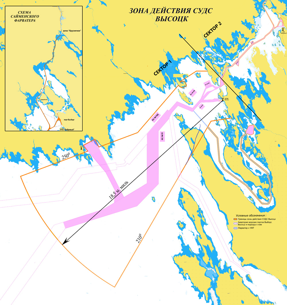
 The transitional border for vessels passing through the Saint Petersburg VTS area as the Regional VTS and the VTS of Vysotsk seaport is the water area of the Gulf of Finland limited with an arc of circle with the radius of 18.5 nautical miles (the water area of the seaports of Vyborg and Vysotsk, the waters of the Big and Small Tranzund raids) with the center at the point 60°35'47"N and 28°33'63" E and its radii drawn along the 210° and 250° directions.
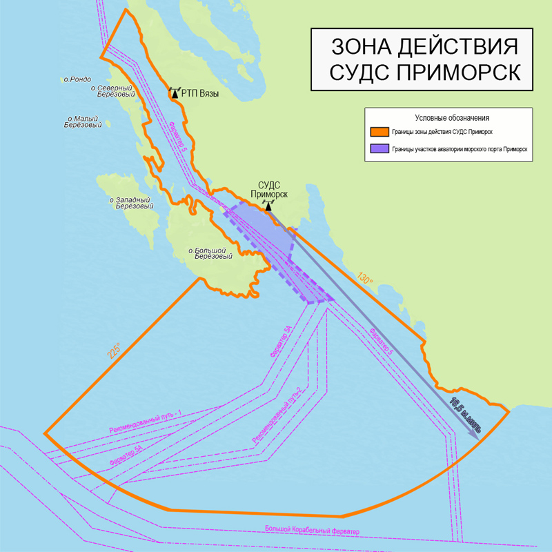
The transitional border for vessels passing through the Saint Petersburg VTS area as the Regional VTS and the VTS of Primorsk Seaport is the water area of the Bierkesund Strait to the south of the 60°25.00'N parallel and the Gulf of Finland, bounded by an arc of a circle with a radius of 16.5 nautical miles centered at coordinates 60°20'25"N and 28°43'23" E and its radii drawn along the 130° and 225° directions.
The transitional border for vessels passing through the Saint Petersburg VTS area as the Regional VTS and the VTS of Ust-Luga Seaport is the water area of the Gulf of Finland between an arc of a circle with a radius of 18.5 nautical miles centered at the coordinates 59 ° 47'90 "N and 028 ° 29 ' 80 "E and its radii drawn along the 200° and 90° directions.
The GOFREP system covers the international waters of the Gulf of Finland, the borders of which are defined in the resolution MSC.231(82), approved on December 5, 2006.

Vysotsk VTS coverage area
 In accordance with Compulsory Regulations of the
seaport of Vyborg approved by the Ministry of Transport of the Russian
Federation Order No. 300 of September 24, 2025 and Compulsory Regulations of the seaport of Vysotsk approved
by the Ministry of Transport of the Russian Federation Order No.
273 of September 04, 2025, Vysotsk VTS Coverage Area
borders are:
In accordance with Compulsory Regulations of the
seaport of Vyborg approved by the Ministry of Transport of the Russian
Federation Order No. 300 of September 24, 2025 and Compulsory Regulations of the seaport of Vysotsk approved
by the Ministry of Transport of the Russian Federation Order No.
273 of September 04, 2025, Vysotsk VTS Coverage Area
borders are:
- the Gulf of Finland water area limited by an arch of a circle with the center in 60º35'47"N latitude and 28º33'63" longitude, with the radius of 18.5 sea miles between the radii of 210˚ and 250˚ directions;
- water areas of the seaports of Vyborg and Vysotsk (excluding anchorages No. 18E and No. 18ZH);
- water areas of the Big and Lesser Tranzundsky roads, bounded by a straight line connecting the points with coordinates: Latitude = 60°34'N Longitude 028°35,37'E, Latitude = 60°32,74'N Longitude = 028°18.64'E, followed by a straight line to a point with coordinates: Latitude = 60°36,83'N Longitude = 028°25,95'E, then the coastline east of the island stern to the point with coordinates: Latitude = 60°37.07'N Longitude = 028°26,15'E, followed by straight lines through the point with coordinates: Latitude = 60°38'N Longitude = 028°29'E to the point with coordinates: Latitude = 60°38'N Longitude = 028°31,1'Е
In following zones the Vysotsk VTS:
- in the area of the Vyborg sea channel from the point with coordinates: Latitude = 60°37,45'N Longitude = 028°33,509'E (Western Pinkel light) to the point with coordinates: Latitude = 60°38,50'N Longitude = 028°35,30'E (Ityapalu sign of the left side);
- on Saimaa fairway from the point with coordinates: Latitude = 60°43,77'N Longitude = 028°40,66'E (Gvardeisky island) To the point with coordinates: Latitude = 60°48,47'N Longitude = 028°44,22'E (Brusnichnoe gateway);
- on the recommended path to the remote marine terminal located at Putevoy Cape, from the point with coordinates: Latitude = 60°29,32'N Longitude = 028°34,48'E to the point with coordinates: W = 60°32,6'N Longitude = 028°37,77'E and remote waters of the marine terminal located at Putevoy Cape, performs its functions using the data from the Automatic Identification System.
 Kaliningrad VTS coverage area
The Kaliningrad VTS coverage area includes:
• territorial
sea area bounded by a circle with a radius of seven nautical miles drawn from the end of the northern pier of the entrance gate of the seaport of Kaliningrad;
• the seaport of Kaliningrad water area from entering malls till survey mark № 350;
• Kaliningrad Bay.
 Primorsk VTS coverage area
In
accordance with Compulsory Regulations of the seaport of Primorsk, approved by
the Ministry of Transport of the Russian Federation Order No. 244 of August 18, 2025,
Primorsk VTS coverage area includes:
- water area of the Bierkesund Strait southward the line with coordinates 60°30,78'N and 028°28,13'Е и 60°28,30'N и 028°25,23'Е;
- water area of the Gulf of Finland limited by a circle with the center in 60°20,25'N latitude and 028°43,23'E longitude, and the radius of 16,5 miles between the radii of 130° and 225° directions.
 Ust-Luga VTS coverage area
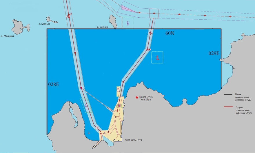
In accordance with the Compulsory Regulations in the Seaport of Ust-Luga, approved by the Ministry of Transport of Russia order dated 04.09.2024 No. 304, the coverage area of the Ust-Luga VTS is adjacent to the coverage area of the St. Petersburg VTS and extends to the waters of the Luga and Koporskaya Bays of the eastern part of the Gulf of Finland, bounded from the west by the 028°00.00' E meridian and from the north by the 60°00.00' N parallel, from the east by the 029°00.00' E meridian and from the south by the coastline.
Coverage areas of all VTS of the North-Western Basin Branch have the necessary equipment to maintan VHF radio communication with vessels and radar control. Working areas of AIS base stations completely cover the respective VTS area.
Detection and guaranteed sustainable support of vessels with effective reflective surface of 100 sq.m. and more is provided in RVTS and VTS of the port of Kaliningrad coverage areas, and reliable VHF radio communication with ships and radar control are guaranteed. The working area of coast stations of the Automatic Identification System (AIS) completely covers the RVTS and VTS of the port of Kaliningrad coverage areas.
3. Terms and conditions of navigation VTS services
Terms and conditions of navigation VTS services with the use of Saint Petersburg VTS
The FSUE “Rosmorport” North-West Basin Branch offers navigation
VTS services with the use of Saint Petersburg VTS to vessels (except for
small boats, pleasure boats and sports sailing ships) according to the requirements of the IMO А.1158(32) Resolution, Common Rules of Navigation and Mooring in the Seaports of the Russian Federation and their approaches, approved by Ministry of Transport order No. 395 of November 12, 2021, Compulsory Regulations in the seaport of Big Port of Saint Petersburg that have been approved by Order No. 388 of December 19, 2016 issued by the Ministry of Transport of Russian Federation, and the Compulsory Regulations in the Passenger port of Big Port of Saint Petersburg that have been approved by Order No. 380 of October 19, 2012 issued by the Ministry of Transport of Russian Federation.
For small boats, pleasure boats and sports sailing ships, Saint Petersburg VTS provides assistance in navigation upon their request within its technical limits.
Irrespective of their departmental identity and forms of property all ships and vessels equipped with radio communication of the marine mobile service in the Saint Petersburg VTS coverage area must comply with the rules for vessel navigation in the Saint Petersburg VTS coverage area.
A regulatory approval system of vessel movement is
effective in the Saint Petersburg VTS coverage area. Vessels enter the Saint Petersburg VTS coverage
area and leave it, approach toward to a pilot’s reception position or
start moving in the zone upon receipt of a Saint Petersburg VTS operator’s permit.
Captains of vessels:
- entering the Saint Petersburg VTS from the west (in the eastern part of the Gulf of Finland) establish a connection with the Saint Petersburg VTS:
a) on VHF Channel 74 (round-the-clock) from the meridian 26°30,00'E to the meridian 28°00,00'E (call sign Petersburg Traffic);
b) on VHF Channel 10 (round-the-clock) from the meridian 28°00,00'E to the meridian 29°12,30'E (call sign Petersburg Traffic).
- calling at the seaport of Big Port St Petersburg or Passenger Port St Petersburg from the east by crossing the meridian 29°12,30'E obtain permit from Saint Petersburg VTS to stop radio watch on VHF Channel 10 and maintain contact with Saint Petersburg VTS on VHF Channel 12 (call sign Petersburg-Radio-9).
- calling at the seaport of Big Port St Petersburg or the Passenger Port St Petersburg from eastward maintain contact with Saint Petersburg VTS on VHF Channel 9 (Petersburg-Radio-9 Call) and are on standby on VHF Channel 9 and on one of the working channels – Channel 12 and Channel 73 or VHF Channel 13 on the instruction of VTMS.
- leaving the seaport of Big Port St Petersburg and the Passenger Port St Petersburg obtain permit from Saint Petersburg VTS to stop radio contact on VHF Channel 12 and maintain contact with Saint Petersburg VTS on VHF Channel 10 (call sign Petersburg Traffic) when crossing the meridian 29°12,30'E.
Vessels entering the Saint Petersburg VTS coverage area must report the following information:
- the name and type of a vessel;
- nationality of a vessel (the flag);
- the port of destination;
- maximum load draught and air draught of a vessel;
- cargo type and transportation of dangerous cargoes;
- the failure of ships’ technical facilities and other restrictions having influence upon navigation safety.
Saint Petersburg VTS is entitled to ask for additional data and information in accordance with the General Rules for Vessel Navigation and Mooring in Russia’s Seaports and on the Approaches Toward Them.
When a vessel enters the Saint Petersburg VTS coverage area, Saint Petersburg VTS identifies the vessel and points it at the route, the procedure for passing fairways and their crossings, an anchoring station and reports on a position of a pilot’s embarkation and the route situation, and transmits other information.
A vessel in the Saint Petersburg VTS coverage area must report to the Saint Petersburg VTS about passing the following mandatory points:
- 26°30,00' Е meridian:
- 28°00,00' Е meridian;
- 29°12,30' E meridian;
- buoys No. 5 and No. 6 of the Approach channel with the coordinates 59°56,9' N 030°10,6' E (buoy No. 5) and 59°57,0' N 030°10,5' E (buoy No. 6);
- lower edge of the Tuchkov Bridge;
- lower edge of the Blagoveshchensky bridge,
and report on the pollution of the marine environment, the inconsistency in the operation or the position of aids to navigation, facilities or the phenomena that pose a threat to or hamper navigation.
After receiving information from the vessel that the mooring has started, Saint Petersburg VTS stops monitoring the vessel’s traffic.
Navigation, current, and other information is transmitted to vessels by the Saint Petersburg VTS on vessel's request or when the situation demands it.
Navigation assistance is rendered to vessels by request, or by decision of the Saint Petersburg VTS under complex
meteorological conditions with no technical equipment to ensure navigation
safety on a vessel, or its failure. While rendering aid to vessel Saint Petersburg VTS regularly
transmits information on:
• the position of a vessel toward a navigation base, a fairway and waypoints;
• dangers to navigation near a vessel and over the entire route;
• on the position and movement of other vessels, as well as recommendations related to further movement of a vessel.
During navigation assistance the Saint Petersburg VTS provides target autotracking mean-square error of no more than:
- 20 meters for distance;
- 0,6º for bearing;
- 2° for course;
- 1 knot for speed.
Compulsory pilotage of vessels is performed by the Saint Petersburg VTS:
- on fairway No. 1 from Saint Petersburg entrance buoy No. 1 to the axial luminous buoy of Kronshtadt ship canal and at Kronshtadt ship canal from mid-channel luminous buoy of the Kronshtadt ship canal to buoys No. 23 and No. 24 of the Saint Petersburg sea canal;
- at the Saint Petersburg sea canal from buoys No. 23 and No. 24 to buoys No. 37 and No. 38A;
- on Petrovsky canal from Saint-Petersburg sea canal to buoys No. 15 and No. 16;
- on fairway No. 11 from Petrovsky canal to Saint Petersburg sea canal;
- on Ship canal from intersection with Petrovsky canal with buoys No. 11 and No. 12;
- on Western Kronshtadt canal;
- on Northern Kronshtadt canal from shipping passage S-2 to the Saint Petersburg sea channel;
- on Lomonosovsky canal.
The procedure for providing assistance in navigation, including the communications interval, is agreed by Saint Petersburg VTS and the vessel using communication means. The vessel is notified by Saint Petersburg VTS about the start and end of assistance in navigation, confirms the receipt of information and recommendations from Saint Petersburg VTS and informs Saint Petersburg VTS about the actions being taken.
The way to control the vessel while following the recommendations and instructions of Saint Petersburg VTS is chosen by the captain of the vessel. If the captain finds it impossible to comply with Saint Petersburg VTS instructions, he must report to the operator of Saint Petersburg VTS using the means of communication and inform him about his further actions and intentions.
The movement of vessels in the Saint Petersburg VTS coverage area is organized due to the specifics of the seaports of Big Port Saint Petersburg and Passenger port Saint Petersburg based on the 24-hour schedule of vessel handling and movement in the seaports of Big Port Saint Petersburg and Passenger port Saint Petersburg and includes:
- issuing permits on vessel movement and its handling in the Saint Petersburg VTS coverage area;
- planning the movement of vessels;
- using vessels’ reports on starting, ending and passing specified points of the route;
- using routes and priority directions of vessels’ movement;
- using one-way movement of vessels in the fairway;
- establishing the speed and the interval of vessels’ movement.
The 24-hour schedule of vessel movement and handling in the seaports of Big Port Saint Petersburg and Passenger Port Saint Petersburg is confirmed by the captains of the respective seaports in compliance with information on the vessel call that has been provided to the captains of the respective seaports and is posted on the Internet:
- seaport of Big Port Saint Petersburg;
- seaport of Passenger Port Saint Petersburg.
Regulation of vessel traffic is performed by the Sain Petersburg VTS exclusively with the use of the automatic identification system:
- from buoys No. 15 and No. 16 of Petrovsky channel to Tuchkov bridge;
- on the Approach channel to the Litke base harbour;
- on the Bolshaya Neva river from southern tip of the berth of the Baltic plant No. 6 to the Blagoveshchensky Bridge;
- on Northern Kronstadt channel from the Saint Petersburg receiving axial luminous buoy No. 2 to shipping passage S-2.
Saint Petersburg VTS regulates vessels’ movement by conveying them binding instructions as follows:
- movement priority and the movement start time;
- the route, the interval and the speed of the movement;
- the procedure for passing fairways and crossing them;
- the ban on further movement;
- anchoring grounds and sheltered locations.
A vessel that has anchored, started or completed mooring to a berth in the seaport Bolshoi Port of Saint or Passenger Port of Saint Petersburg, started moving after unmooring or leaving the berth, should inform Saint Petersburg VTS about it.
Permission to move when unmooring or leaving the berth should be requested by the vessel from Saint Petersburg VTS 15 minutes before the start of movement.
If the vessel hasn't started the permitted movement within the timeframe specified by the Saint Petersburg VTS, the permission should be requested again.
Communication with the vessels in the Saint Petersburg VTS coverage area is carried out round-the-clock on the VHF channels of communication.
A vessel leaving Saint Petersburg VTS coverage area to the east must inform Saint Petersburg VTS and request permission to end the radio watch on VHF working channel 9, call sign “Petersburg-Radio-17”.
A vessel leaving Saint Petersburg VTS coverage area to the west must inform Saint Petersburg VTS and request permission to end the radio watch on VHF working channel 74, call sign “Petersburg-Traffic”.
Information of the channels of communication of very high frequency used in the Saint Petersburg VTS
| Subscriber | VHF channels | Call sign | ||
| Calling | Working | Reserve | ||
| Saint Petersburg VTS of the FSUE “Rosmorport” North-Western Basin Branch | 9 | 9; 13 | 67 | Petersburg – radio-17 |
| 12; 9; 16 | 12; 73; 13 | 67; 30 | Petersburg – radio-19 | |
| 10; 74 | 10; 74 | 10; 74 | Petersburg - Traffic | |
|
Captain Service of the seaport of the Big Port of Saint Petersburg FGBI “AMP Baltic Sea” |
9 | 9 | 67 | Petersburg – radio-5 |
Movement of vessels not equipped with a radiotelephony communication station is not permitted in the Saint Petersburg VTS coverage area.
Vessels in motion as well as vessels moored at anchorages and berths in the seaports of the Big Port of Saint Petersburg and the Passenger Port of Saint Petersburg must maintain a continuous radio watch on VHF channel 9 and in mode of digital selective call (hereinafter - DSC) on VHF channel 70.
Using VHF channels for communication between coast correspondents is not permitted.
Communication between VTS and vessels must be carried out in accordance with Radio Regulations of the Marine Mobile Service and the Marine Mobile Satellite Service, approved by the Ministry of Transport of Russia order No. 486 of December 9, 2022. English is used in terms of “IMO Standard Phrases for Communication at Sea” for voice radio communication with the crew of a foreign vessel. Sending messages from vessels to VTS and the message format must, where possible, meet the Resolution IMO A.851 (20) “General Concepts of Ship Reporting Systems and Ship Reporting Requirements”.
Necessary information for vessels owners and other users entering Saint Petersburg VTS coverage area and performance requirements of VTS in a standardized form is also available at the information map of the Russian Federation Ministry of Defence GUNiO No. 92600, published in the “Notices to Mariners”.
Navigation dues are charged for navigation services rendered by the North-Western Basin Branch with the help of Saint Petersburg VTS to vessels performing port calls at the seaports of the Big Port of Saint Petersburg, Passenger Port of Saint Petersburg and Primorsk, and also passing through their water areas by transit. Information on navigation dues rates and the charging procedure is available in the section “Harbor Dues and Tariffs of the North-Western Basin Branch”.
 |
 |
Terms and conditions of VTS services with the use of Vysotsk VTS
The FSUE “Rosmorport” North-West Basin Branch offers navigation VTS services with the use of Vysotsk VTS to vessels (except for small boats, pleasure boats and sports sailing ships) accordance with the requirements of IMO A.1158(32) Resolution, the General Rules for the Navigation and Mooring of Vessels in the Seaports of the Russian Federation and on the Approaches toward them that have been approved by the Order No. 395 of November 12, 2021 issued by the Ministry of Transport of the Russian Federation, the Compulsory Regulations in the seaport of Vysotsk that have been approved by the Order No. 273 of 04.09.2025 issued by the Ministry of Transport of the Russian Federation and the Compulsory Regulations in the Vysotsk Seaport that have been approved by Order No. 300 of 24.09.2025 issued by the Ministry of Transport of the Russian Federation.
Small boats, pleasure boats and sports sailing ships, located in the coverage area of Vysotsk VTS, can be provided with assistance in navigation only, upon their request and within technical limits of the VTS equipment.
All ships and vessels remaining in the Vysotsk VTS coverage area regardless of their ownership must meet the requirements of the Vysotsk VTS.
A regulatory approval system of vessel movement is effective in the Vysotsk VTS coverage area. Vessels enter the Vysotsk VTS coverage area and leave it, approach toward to a pilot’s reception position or start moving in the zone upon receipt of a Vysotsk VTS operator’s permit.
Captains of vessels moving to the seaports of Vyborg, Vysotsk and the Saimaa Canal from the sea using the vessel traffic separation system, on the approaches to the Vyborg Bay when crossing the parallel 60°23.9' N, and following from the side of the Republic of Finland along fairway No. 4 when crossing the meridian 028°00.6' E, receive permission from the Saint Petersburg VTS to cease radio watch on VHF channel 74 and must contact Vysotsk VTS while entering the coverage area on VHF Channel 9 (the Vysotsk -Traffic call sign), take a recognition signal and transmit the following data on:
- the name and type of a vessel;
- nationality of a vessel (the flag);
- the port of destination;
- maximum load draught and air draught of a vessel;
- cargo type and transportation of dangerous cargoes;
- the failure of ships’ technical facilities and other restrictions having influence upon navigation safety,
and receive permission to start movement.
Vysotsk VTS is entitled to ask for additional data and information in accordance with the General Rules for Vessel Navigation and Mooring in Russia’s Seaports and on the Approaches Toward Them.
When a vessel enters the Vysotsk VTS coverage area, Vysotsk VTS identifies the vessel and points it at the route, the procedure for passing fairways and their crossings, an anchoring station and reports on a position of a pilot’s embarkation and the route situation, and transmits other information.
Vessels in the coverage area
of Vysotsk VTS must report to the Vysotsk VTS on passing the compulsory
boundaries (on Channel 9):
a) broad on the beam of the Khallikivi marine light and the Ityapalu left light buoy (on VHF Channel 12);
b) on passing the Lotsmansky fairway buoy of the southern entrance to the Vysotsk inner roadstead of the southern extreme point of Zaovrazhesky Island (on VHF Channel 9);
c) on passing the western Pinkeli light buoy and the left side Ityapalu light buoy on the vessel's beam.
Vessels must inform Vysotsk VTS about facts of marine pollution and disparity in the operation and location of aids to navigation, facilities or developments, which pose a danger to or prevent navigation.
Pursuant to the Compulsory Regulations in the Seaport of Vysotsk vessels, which make navigation on the approaches toward the seaport of Vysotsk and in the water area of the seaport of Vysotsk, transmit information on VHF Channel 9 as follows:
- on anchoring, un-anchoring of vessel;
- starting and ending vessel movement;
- on embarkation of a pilot on a vessel and the disembarkation of a pilot from a vessel;
- the expected time of approaching berths and anchoring stations of the seaport of Vysotsk.
For their turn, pursuant to the Compulsory Regulations in the seaport of Vyborg vessels in the seaports of Vyborg must inform Vysotsk VTS on VHF Channel 12 on:
- starting and ending pilotage;
- on the commencement of a vessel's movement upon weighing anchor, or on the vessel's departure from the seaport berths;
- on the anchoring of a vessel, or on the mooring of a vessel to a seaport berth;
- on the commencement of a vessel's movement along the Saimaa Fairway to the Brusnichnoe Lock or from the Brusnichnoe Lock to the Saimaa Fairway;
After receiving information from the vessel that the mooring has started, Vysotsk VTS stops monitoring the vessel’s traffic.
Vysotsk VTS transmits navigational, operational and other information at the request of a vessel or by order of the captain of the seaport of Vysotsk when the navigation situation changes or may change, when a storm warning is received, or upon other changes can influence navigation safety in the Vysotsk VTS coverage area. In particular, in accordance with the Compulsory Regulations in the seaport of Vysotsk, the movement of vessels with dangerous goods on board, passenger vessels and vessels with malfunctioning technical equipment in the waters of the seaport of Vysotsk with visibility of 20 cables or less is permitted, provided that the Vysotsk VTS operator provides assistance to the captains of the vessels in navigation.
Vysotsk VTS provides aid to vessels at the request of a vessel or by a decision taken by Vysotsk VTS under complex meteorological conditions with no technical equipment to ensure navigation safety on a vessel, or its failure. While rendering aid to vessel Vysotsk VTS regularly transmits information on:
- the position of a vessel toward a navigation base, a fairway and waypoints;
- dangers to navigation near a vessel and over the entire route;
- on the position and movement of other vessels, as well as recommendations related to further movement of a vessel.
When rendering aid to vessels Vysotsk VTS ensure radar autonomous tracking accurate to no more than:
• 25 meters for distance;
• 0,8º for bearing;
• 3° for course;
• 1,5 knots for speed.
The procedure for providing assistance in navigation, including the communications interval, is agreed by Vysotsk VTS and the vessel using communication means. The vessel is notified by Vysotsk VTS about the start and end of assistance in navigation, confirms the receipt of information and recommendations from Vysotsk VTS and informs Vysotsk VTS about the actions being taken.
The way to control the vessel while following the recommendations and instructions of Vysotsk VTS is chosen by the captain of the vessel. If the captain finds it impossible to comply with Vysotsk VTS instructions, he must report to the operator of Vysotsk VTS using the means of communication and inform him about his further actions and intentions.
The movement of vessels in the Vysotsk VTS coverage area is organized due to the specifics of the seaports of Vyborg and Vysotsk based on the 24-hour schedule of vessel handling and movement in the seaport of Vysotsk and includes:
- issuing permits on vessel movement and its handling in the Vysotsk VTS coverage area;
- planning the movement of vessels;
- using vessels’ reports on starting, ending and passing specified points of the route;
- using routes and priority directions of vessels’ movement;
- using one-way movement of vessels in the fairway;
- establishing the speed and the interval of vessels’ movement.
The 24-hour schedule of vessel movement and handling in the seaports of Vyborg and Vysotsk is confirmed by the captains of the seaports of Vyborg and Vysotsk in compliance with information on the vessel calls transmitted to the captains of the respective seaports and posted on the Internet:
Vysotsk VTS regulates vessels’ movement by conveying them binding instructions related to:
- movement priority and the movement start time;
- the route, the interval and the speed of the movement;
- the procedure for passing fairways and crossing them;
- the ban on further movement;
- anchoring grounds and sheltered locations.
A vessel that has anchored, started or completed mooring to a berth in the seaport of Vyborg or seaport of Vysotsk, started moving after unmooring or leaving the berth, should inform Vysotsk VTS about it.
Permission to move when unmooring or leaving the berth should be requested by the vessel from Vysotsk VTS 20 minutes before the start of movement.
Permission is canceled and must be requested again, if the vessel did not start the allowed actions within 20 minutes.
The main means of interaction between the Vysotsk VTS and vessels in its area of operation is radiotelephone communication in the VHF range of the maritime mobile service.
Vessels navigating in the Vysotsk VTS coverage area must keep constant radio watch on UHF channels 9 and 12, and also on the instructions of the Vysotsk VTS on VHF communication channels 73 or 75 (call sign – “Vysotsk-Traffic”).
A vessel leaving Vysotsk VTS coverage area must inform Vysotsk VTS and request permission to end the radio watch on VHF working channel 9, call sign “Vysotsk-Traffic”.
A vessel leaving the seaports of Vysotsk and Vyborg by Vessels Movement
Separation Scheme on the approaches toward the Bay of Vyborg by crossing
the circle of longitude 60 degrees 23.9 minutes North and vessels
moving along the pilot’s fairway No. 4 by crossing the circle of
latitude 028 degrees 00.6 minutes East should get permission of the Vysotsk VTS
to cease radio contacts on VHF Channel 9 and establish contact with the port of
Saint Petersburg VTS on VHF Channel 74 with the “Petersburg-Traffic” callsign.
Information about the communication channels of very high frequency used in the Vysotsk VTS coverage area
| Subscriber | VHF channels | Call sign | ||
| calling channel | working channel | reserve channel | ||
| Vysotsk VTS of the FSUE “Rosmorport” North-Western Basin Branch |
9 |
9, 73, 75 |
12 |
Vysotsk - Traffic |
| Saint Petersburg VTS of the FSUE “Rosmorport” North-Western Basin Branch | 10; 74 | 10; 74 | 10; 74 | Petersburg - Traffic |
| Central Service Post of the Captain of the seaport of Vysotsk FGBI “AMP Baltic Sea” | 12 | 12 | 68 | Vyborg – radio-5 |
Communication not related to navigation safety, as well as using communication channels for communication between coast correspondents on the abovementioned channels of VHF in the seaports of Vyborg and Vysotsk is not allowed.
Information about the additional means of communication for the transmission of information, including phone numbers, is announced by the captains of the seaports Vyborg and Vysotsk.
Communication between the Vysotsk VTS and the vessels must be carried out in accordance with the Radio Regulations of the Marine Mobile Service and the Marine Mobile Satellite Service, approved by the Ministry of Transport of Russia order No. 486 of December 9, 2022. English is used in terms of "IMO Standard phrases for communication at sea" for voice radio contact with the crew of a foreign vessel. Sending messages from vessels to the VTS and the message format should, when possible, meet the Resolution IMO A.851(20) "General Principles for Vessel Reporting Systems and Vessel Reporting Requirements”.
Navigation dues are charged for navigation services rendered by the North-West Basin Branch with the help of the Vysotsk VTS to vessels performing port calls to the seaports of Vyborg and Vysotsk, or passing through their water areas, and also crossing the Saimaan canal. Information on navigation dues rates in the seaports of Vyborg and Vysotsk and the charging procedure is available in the section “Harbor Dues and Tariffs of the North-Western Basin Branch”.
 |
 |
Terms and conditions of VTS services with the use of the Kaliningrad VTS
The FSUE “Rosmorport” North-West Basin Branch offers navigation VTS
services with the use of Kaliningrad VTS to vessels (except for small
boats, pleasure boats and sports sailing ships) according to the IMO A.1158(32) Resolution of the General Rules of navigation and mooring in the seaports of the Russian Federation and the approaches to them, approved by order of the Ministry of Transport of the Russian Federation No.395 of 12.11.2021 and Compulsory regulations in the seaport of Kaliningrad, approved by Ministry of Transport of the Russian Federation Order No. 335 of 11.05.2013.
For small boats, pleasure boats and sports sailing ships, Kaliningrad VTS provides assistance in navigation upon their request within its technical limits.
All ships and vessels within VTS of the port of Kaliningrad coverage area, regardless of their departmental affiliation and forms of ownership, must meet the requirements of VTS of the port of Kaliningrad.
A regulatory approval system of vessel movement is effective in the Kaliningrad VTS coverage area. Vessels enter the Kaliningrad VTS coverage area and leave it, approach toward to a pilot’s reception position or start moving in the zone upon receipt of a Kaliningrad VTS operator’s permit.
Captains of vessels, including autonomous vessels, that proceed to the sea terminals of the seaport of Kaliningrad from the sea and from the Vistula Lagoon, must contact Kaliningrad VTS while entering the Kaliningrad VTS coverage area on VHF Channel 74 (Baltiysk-traffic call sign), take a recognition signal and transmit the following data on:
- the name and type of a vessel;
- nationality of a vessel (the flag);
- the port of destination;
- maximum load draught and air draught of a vessel;
- cargo type and transportation of dangerous cargoes;
- the failure of ships’ technical facilities and other restrictions having influence upon navigation safety.
Kaliningrad VTS is entitled to ask for additional data and information in accordance with the General Rules for Vessel Navigation and Mooring in Russia’s Seaports and on the Approaches Toward Them.
When a vessel enters the Kaliningrad VTS coverage area, Kaliningrad VTS identifies the vessel and points it at the route, the procedure for passing fairways and their crossings, an anchoring station and informs about the pilot’s embarkation and the route situation, and transmits other information.
A vessel in the Kaliningrad VTS coverage area has to report on the pollution of the marine environment, the inconsistency in the operation or the position of aids to navigation, facilities or the phenomena that pose a threat to or hamper navigation.
When entering and leaving the seaport of Kaliningrad, autonomous vessels must anchor at anchorage No. 68 at the point indicated by Kaliningrad VTS to board (disembark) a pilot (for fully autonomous vessels — a pilot and a representative (representatives) of the owner of the fully autonomous vessel who has the appropriate qualifications for operating the vessel and ensuring its safe movement and mooring).
After receiving information from the vessel that the mooring has started, Kaliningrad VTS stops monitoring the vessel’s traffic.
Kaliningrad VTS transmits navigational, operational and other information at the request of a vessel or by order of the master of the seaport of Kaliningrad when the navigation situation changes or may change, when a storm warning is received, or upon other changes can influence navigation safety in the Kaliningrad VTS coverage area.
Kaliningrad VTS provides aid to vessels at the request of a vessel or by a decision taken by Kaliningrad VTS under complex meteorological conditions with no technical equipment to ensure navigation safety on a vessel, or its failure.
Kaliningrad VTS provides aid to vessels on the approach fairway to the seaport No. F-35, in the water area of the seaport of Kaliningrad from entrance piers (survey mark No. 27a) to survey mark No. 350 and on the recommended routes No. 34 and No. 35 of the Kaliningrad Bay.
While rendering aid Kaliningrad VTS regularly transmits to the vessel information on:
- the position of a vessel toward a navigation base, a fairway and waypoints;
- dangers to navigation near a vessel and over the entire route;
- on the position and movement of other vessels, as well as recommendations related to further movement of a vessel.
When rendering aid to vessels Kaliningrad VTS ensure radar autonomous tracking accurate to no more than:
- no more than 20 meters in distance;
- no more than 0.6° in azimuth;
- no more than 2° in direction of movement;
- no more than 1 knot in movement speed.
In the Kaliningrad VTS coverage area AIS transmits information on differential corrections of GLONASS/GPS monitoring and correcting stations.
The procedure for providing assistance in navigation, including the communications interval, is agreed by Kaliningrad VTS and the vessel using communication means. The vessel is notified by Kaliningrad VTS about the start and end of assistance in navigation, confirms the receipt of information and recommendations from Kaliningrad VTS and informs Kaliningrad VTS about the actions being taken.
The way to control the vessel while following the recommendations and instructions of Kaliningrad VTS is chosen by the captain of the vessel. If the captain finds it impossible to comply with Kaliningrad VTS instructions, he must report to the operator of Kaliningrad VTS using the means of communication and inform him about his further actions and intentions.
The movement of vessels in the Kaliningrad VTS coverage area is organized due to the specifics of the seaport of Kaliningrad based on the 24-hour schedule of vessel handling and movement in the seaport of Kaliningrad and includes:
- issuing permits on vessel movement and its handling in the Kaliningrad VTS coverage area;
- planning the movement of vessels;
- using vessels’ reports on starting, ending and passing specified points of the route;
- using routes and priority directions of vessels’ movement;
- using one-way movement of vessels in the fairway;
- establishing the speed and the interval of vessels’ movement.
The 24-hour schedule of vessel movement and handling in the seaport of Kaliningrad is confirmed by the captain of the seaport of Kaliningrad in compliance with information on the vessel call that has been given to the master of the seaport of Kaliningrad and posted on the Internet: http://www.pasp.ru/traffic.
Kaliningrad VTS regulates vessels’ movement by conveying them binding instructions as follows:
- movement priority and the movement start time;
- the route, the interval and the speed of the movement;
- the procedure for passing fairways and crossing them;
- the ban on further movement;
- anchoring grounds and sheltered locations.
In the section of the water area of the seaport of Kaliningrad from survey mark No. 350 to the centerline buoy 1, at the anchorages of the seaport and on the recommended routes of the Kaliningrad Bay, the navigation of vessels is regulated by Kaliningrad VTS on VHF Channel 74, Baltiysk-traffic call sign.
Vessels are anchored according to the instructions of Kaliningrad VTS, which informs the vessel of the anchorage number and the coordinates of the anchorage point, and, if necessary or at the vessel’s request, provides navigational assistance and informs the vessel of the direction and distance to the anchorage.
A vessel that has anchored, started or completed mooring to a berth in the seaport of Kaliningrad, started moving after unmooring or leaving the berth, should inform Kaliningrad VTS about it.
Vessels moored at anchorages should receive meteorological information from coastal weather stations and Kaliningrad VTS, keep the main engine and anchor gear ready to raise anchor and make speed to leave the anchorage according to the deterioration of the weather conditions independently or on the recommendation of Kaliningrad VTS.
Permission to move when unmooring or leaving the berth should be requested by the vessel from Kaliningrad VTS before the start of movement.
Permission is canceled and must be requested again, if the vessel did not start the allowed actions within 20 minutes.
The main means of communication between the Kaliningrad VTS and the vessels is VHF radio and telephone communication of mobile marine service. Vessels in the Coastal VTS coverage area shall keep constant radio watch on the Coastal VTS working channels:
• 74 – main;
• 69 – alternative;
• 16 – emergency.
Vessels under way, as well as standing on the anchorages are required to carry a constant radio watch on 67 or 74 VHF channels; vessels standing at berths of port cargo terminals – on 14 VHF channel.
In the Kaliningrad VTS coverage area, vessels, including autonomous vessels, must maintain communication with Kaliningrad VTS on VHF Channel 74. In the navigation control and management service coverage area, vessels, including autonomous ones, must maintain communication on VHF Channel 67.
A vessel leaving Kaliningrad VTS coverage area must inform Kaliningrad VTS and request permission to end the radio watch on VHF working channel 74, Baltiysk-traffic call sign.
Information about the communication channels of very high frequency used in the Kaliningrad VTS coverage area
| Subscriber | VHF channels | Call sign |
| Kaliningrad VTS of the FSUE “Rosmorport” North-Western Basin Branch | 74, 16 (69 reserve) | Baltiysk-traffic |
| NCMS of the city of Kaliningrad | 67 | Kaliningrad-Port-Control |
| Port state control in the city of Kaliningrad FGBI “AMP Baltic Sea” | 14 | Kaliningrad-5 |
| Port state control in the town of Svetly FGBI “AMP Baltic Sea” | 11 | Svetly-49 |
| Port state control in the town of Baltiysk FGBI “AMP Baltic Sea” | 14 | Baltiysk-5 |
| Port state control in the town of Pionersky FGBI “AMP Baltic Sea” | 11 | Pionersky-49 |
Communication not related to maritime safety is not allowed on 11, 14, 16, 67, 69 and 74 VHF channels in the seaport of Kaliningrad.
The Kaliningrad VTS and the vessels must communicate according to the Radio Regulations of the Marine Mobile Service and the Marine Mobile Satellite Service, approved by the Ministry of Transport of Russia order No. 486 of December 9, 2022. Oral communication with a foreign vessel is performed in English according to “IMO Standard Marine Communication Phrases”. Messages transmitted from vessels to the Kaliningrad VTS must, if possible, comply to the IMO Resolution А.851(20) “General Principles of Ship Reporting and Ship Reporting Requirements”.
Navigation dues are charged for navigation services rendered by the Kaliningrad Department of the North-West Basin Branch with the help of the Kaliningrad VTS to vessels performing port calls to the seaport of Kaliningrad, and also passing through its water area by transit. Information on navigation dues rates and the charging procedure is available in the section “Harbour Dues and Tariffs of the North-Western Basin Branch”.
 |
 |
Terms and conditions of navigation VTS services with the use of Primorsk VTS
North-Western Basin Branch provides navigation services using the Primorsk VTS to vessels (except for small boats, pleasure boats and sports sailing ships) according to IMO A.1158(32) Resolution, the General Rules of navigation and mooring vessels in the seaports of Russian Federation and on the approaches to them, approved by order No. 395 of 12.11.2021 of the Ministry of Transport of the Russian Federation and Compulsory regulations in the seaport of Primorsk, approved by Ministry of Transport of the Russian Federation Order No. 244 of 18.08.2025.
For small boats, pleasure boats and sports sailing ships, Primorsk VTS provides assistance in navigation upon their request within its technical limits.
Irrespective of their departmental identity and forms of property all ships and vessels equipped with radio communication of the marine mobile service in the Primorsk VTS coverage area must comply with the rules for vessel navigation in the Primorsk VTS coverage area.
A regulatory approval system of vessel movement is effective in the Primorsk VTS coverage area. Vessels enter the Primorsk VTS coverage area and leave it, approach toward to a pilot’s reception position or start moving in the zone upon receipt of a Primorsk VTS operator’s permit.
Vessel entering the Primorsk VTS coverage area after leaving Saint Petersburg VTS coverage area shall receive permission from the Saint Petersburg VTS to cease radio watch on VHF channel 10, call sign “Saint- Petersburg – Traffic”, and establish a connection with the VTS of the port of Primorsk on VHF channel 68, call sign “Primorsk – Traffic”. At the request of the VTS of the port of Primorsk operator, vessels shall transmit information on:
- the name and type of a vessel;
- nationality of a vessel (the flag);
- the port of destination;
- maximum load draught and air draught of a vessel;
- cargo type and transportation of dangerous cargoes;
- presence of technical faults and other limitations which influence navigation safety,
and receive permission from the Center of the Primorsk VTS to enter its coverage area.
Primorsk VTS is entitled to ask for additional data and information in accordance with the General Rules for Vessel Navigation and Mooring in Russia’s Seaports and on the Approaches Toward Them.
When a vessel enters the Primorsk VTS coverage area, Primorsk VTS identifies the vessel and points it at the route, the procedure for passing fairways and their crossings, an anchoring station and reports on a position of a pilot’s embarkation and the route situation, and transmits other information.
A vessel in the Primorsk VTS coverage area has to report on the pollution of the marine environment, the inconsistency in the operation or the position of aids to navigation, facilities or the phenomena that pose a threat to or hamper navigation.
After receiving information from the vessel that the mooring has started, Primorsk VTS stops monitoring the vessel’s traffic.
Primorsk VTS transmits navigational, operational and other information at the request of a vessel or by order of the captain of the seaport of Primorsk when the navigation situation changes or may change, when a storm warning is received, or upon other changes can influence navigation safety in the Primorsk VTS coverage area.
Primorsk VTS provides aid to vessels at the request of a vessel or by a decision taken by Primorsk VTS under complex meteorological conditions with no technical equipment to ensure navigation safety on a vessel, or its failure. While rendering aid to vessel Primorsk VTS regularly transmits information on:
• the position of a vessel toward a navigation base, a fairway and waypoints;
• dangers to navigation near a vessel and over the entire route;
• on the position and movement of other vessels, as well as recommendations related to further movement of a vessel.
When rendering navigation assistance the Primorsk VTS provides target autotracking mean-square error of no more than:
- 20 meters for distance;
- 0.6° for azimuth;
- 2° for course;
- 1 knots for movement speed.
The procedure for providing assistance in navigation, including the communications interval, is agreed by Primorsk VTS and the vessel using communication means. The vessel is notified by Primorsk VTS about the start and end of assistance in navigation, confirms the receipt of information and recommendations from Primorsk VTS and informs Primorsk VTS about the actions being taken.
The way to control the vessel while following the recommendations and instructions of Primorsk VTS is chosen by the captain of the vessel. If the captain finds it impossible to comply with Primorsk VTS instructions, he must report to the operator of Primorsk VTS using the means of communication and inform him about his further actions and intentions.
The movement of vessels in the Primorsk VTS coverage area is organized due to the specifics of the seaport of Primorsk based on the 24-hour schedule of vessel handling and movement in the seaport of Primorsk and includes:
- issuing permits on vessel movement and its handling in the Primorsk VTS coverage area;
- planning the movement of vessels;
- using vessels’ reports on starting, ending and passing specified points of the route;
- using routes and priority directions of vessels’ movement;
- using one-way movement of vessels in the fairway;
- establishing the speed and the interval of vessels’ movement.
The 24-hour schedule of vessel movement and handling in the seaport of Primorsk is confirmed by the captain of the seaport of Primorsk in compliance with information on the vessel call that has been given to the captain of the seaport of Primorsk, and is published on the Internet: http://skap.pasp.ru/Plan/SgdsDayList?harb=PRIM.
Primorsk VTS regulates vessels’ movement by conveying them binding instructions as follows:
- movement priority and the movement start time;
- the route, the interval and the speed of the movement;
- the procedure for passing fairways and crossing them;
- the ban on further movement;
- anchoring grounds and sheltered locations.
Regulation of vessel traffic is carried out by the Primorsk VTS using an automatic identification system in an area limited by straight lines connecting in order the points with coordinates:
№ 1 lat.=60°21,60' N long.=028°35,92' E;
№ 2 lat.=60°21,62' N long.=028°36,12' E;
№ 3 lat.=60°21,28' N long.=028°36,25' E;
№ 4 lat.=60°21,24' N long.=028°36,19' E;
№ 5 lat.=60°21,27' N long.=028°36,09' E.
A vessel that has anchored, started or completed mooring to a berth in the seaport of Primorsk, started moving after unmooring or leaving the berth, should inform Primorsk VTS about it.
Permission to move when unmooring or leaving the berth should be requested by the vessel from Primorsk VTS before the start of movement.
If the vessel has not started moving within the time designated by the Primorsk VTS, permission to start moving is requested by the vessel again.
Vessels located in the Primorsk VTS coverage area shall keep constant radio watch on VHF 16 and 68 communication channels.
Captains of vessels proceeding from the Primorsk VTS coverage area to the Saint Petersburg VTS coverage area must obtain permission from the Primorsk VTS to cease radio watch on VHF channel 68 (call sign "Primorsk-traffic") and establish contact with the Saint Petersburg VTS on VHF channel 10 (call sign "Petersburg-traffic").
Information of the channels of communication of very high frequency used in the seaport of Primorsk
| Subscriber | VHF Channels | Call sign | |
| working | reserve | ||
| Primorsk VTS of the FSUE “Rosmorport” North-Western Basin Branch | 68 | 9 | Primorsk - Traffic |
| Saint PetersburgVTS of the FSUE “Rosmorport” North-Western Basin Branch | 10; 74 | - | Petersburg - Traffic |
|
State Port Control Service in the seaport FGBI “AMP Baltic Sea” |
9 | 67 | Primorsk - Portcontrol |
Navigating in the Primorsk VTS coverage area in the absence of radio communication between the vessel's captain and the Primorsk VTS is not allowed.
Radio communication between the Primorsk VTS operators and vessels must be performed in accordance with the Radio Regulations of the Marine Mobile Service and the Marine Mobile Satellite Service, approved by the Ministry of Transport of Russia order No. 486 of December 9, 2022. Communication with foreign vessel crews is performed in English according to “IMO Standard Marine Communication Phrases”. Messages transmitted from vessels to the VTS of the port of Primorsk must, if possible, comply with the IMO Resolution А.851(20) “General Principles of Ship Reporting and Ship Reporting Requirements”.
Navigation dues are charged for navigation services rendered by the North-West Basin Branch with the help of the Primorsk VTS to vessels performing port calls to the seaport of Primorsk, and also passing through its water area by transit. Information on navigation dues rates and the charging procedure is available in the section “Harbor Dues and Tariffs of the North-Western Basin Branch”.
 |
 |
Terms and conditions of navigation VTS services with the use of the Ust-Luga VTS
The FSUE “Rosmorport” North-West Basin
Branch offers navigation VTS services with the use of Ust-Luga VTS to
vessels (except for small boats, pleasure boats and sports sailing
ships) according to the IMO A.1158(32) Resolution, General Rules of Navigation and Mooring in the Seaports of the Russian Federation and on approaches to them approved by Ministry of Transport Order No. 395 of 12.22.2021, and Compulsory Regulations in seaport Ust-Luga approved by Ministry of Transport of the Russian Federation Order No. 304 of 04.09.2024.
Small boats, pleasure boats and sports sailing ships, located in the coverage area of Ust-Luga VTS, can be provided with assistance in navigation only, upon their request and within technical limits of the VTS equipment.
Irrespective of their departmental identity and forms of property all ships and vessels equipped with radio communication of the marine mobile service in the Ust-Luga VTS coverage area must comply with the rules for vessel navigation in the Ust-Luga VTS coverage area.
A regulatory approval system of vessel movement is effective in the Ust-Luga VTS coverage area. Vessels enter the Ust-Luga VTS coverage area and leave it, approach toward to a pilot’s reception position or start moving in the zone upon receival of a Ust-Luga VTS operator’s permit.
Masters of the vessels, including fully autonomous vessels, heading from the sea towards the Ust-Luga VTS coverage area must make contact with the VTS on the VHF channel 69 an hour before entering, the call sign is “Ust-Luga-Traffic”, receive confirmation of identification, and transmit the following information:
- the name and type of a vessel;
- nationality of a vessel (the flag);
- the port of destination;
- maximum load draught and air draught of a vessel;
- cargo type and transportation of dangerous cargoes;
- presence of technical faults and other limitations which influence navigation safety,
and receive authorization of the Ust-Luga VTS Center to enter (exit) the Ust-Luga VTS coverage area.
Ust-Luga VTS is entitled to ask for additional data and
information in accordance with the General Rules for Vessel Navigation and
Mooring in Russia’s Seaports and on the Approaches Toward Them.
When a vessel enters the Ust-Luga VTS coverage area, Ust-Luga VTS identifies the vessel and points it at the route, the procedure for passing fairways and their crossings, an anchoring station and reports on a position of a pilot’s embarkation and the route situation, and transmits other information.
A vessel in the Ust-Luga VTS coverage area has to inform the Ust-Luga VTS about the pollution of the marine environment, the inconsistency in the operation or the position of aids to navigation, facilities or the phenomena that pose a threat to or hamper navigation.
After receiving information from the vessel that the mooring has started, Ust-Luga VTS stops monitoring the vessel’s traffic.
Ust-Luga VTS transmits navigational, operational and other information at the request of a vessel or by order of the captain of the seaport of Ust-Luga when the navigation situation changes or may change, when a storm warning is received, or upon other changes can influence navigation safety in the Ust-Luga VTS coverage area.
Ust-Luga VTS provides aid to vessels at the request of a vessel or by a decision taken by Ust-Luga VTS under complex meteorological conditions with no technical equipment to ensure navigation safety on a vessel, or its failure. While rendering aid to vessel Ust-Luga VTS regularly transmits information on:
• the position of a vessel toward a navigation base, a fairway and waypoints;
• dangers to navigation near a vessel and over the entire route;
• on the position and movement of other vessels, as well as recommendations related to further movement of a vessel.
When rendering navigation assistance the Ust-Luga VTS provides target autotracking mean-square error of no more than:
- 20 meters for distance;
- 0.6° for azimuth;
- 2° for course;
- 1 knots for movement speed.
The procedure for providing assistance in navigation, including the communications interval, is agreed by Ust-Luga VTS and the vessel using communication means. The vessel is notified by Ust-Luga VTS about the start and end of assistance in navigation, confirms the receipt of information and recommendations from Ust-Luga VTS and informs Ust-Luga VTS about the actions being taken.
The way to control the vessel while following the recommendations and instructions of Ust-Luga VTS is chosen by the captain of the vessel. If the captain finds it impossible to comply with Ust-Luga VTS instructions, he must report to the operator of Ust-Luga VTS using the means of communication and inform him about his further actions and intentions.
The movement of vessels in the Ust-Luga VTS coverage area is organized due to the specifics of the seaport of Ust-Luga based on the 24-hour schedule of vessel handling and movement in the seaport of Ust-Luga and includes:
- issuing permits on vessel movement and its handling in the Ust-Luga VTS coverage area;
- planning the movement of vessels;
- using vessels’ reports on starting, ending and passing specified points of the route;
- using routes and priority directions of vessels’ movement;
- using one-way movement of vessels in the fairway;
- establishing the speed and the interval of vessels’ movement.
The 24-hour schedule of vessel movement and handling in the seaport of Ust-Luga is confirmed by the captain of the seaport of Ust-Luga in compliance with information on the vessel call that has been given to the captain of the seaport of Ust-Luga , and is published on the Internet: http://skap.pasp.ru/Plan/SgdsDayList?harb=UL.
Ust-Luga VTS regulates vessels’ movement by conveying them binding instructions as follows:
- movement priority and the movement start time;
- the route, the interval and the speed of the movement;
- the procedure for passing fairways and crossing them;
- the ban on further movement;
- anchoring grounds and sheltered locations.
A vessel that has anchored, started or completed mooring to a berth in the seaport of Ust-Luga, started moving after unmooring or leaving the berth, should inform Ust-Luga VTS about it.
Permission to move when unmooring or leaving the berth should be requested by the vessel from Ust-Luga VTS 15 minutes before the start of movement.
Permission is canceled and must be requested again, if the vessel did not start the allowed actions within within the timeframe specified by Ust-Luga VTS.
Vessels in the coverage area of the Ust-Luga VTS shall keep watch on 14 and 16 VHF Channels, and also, by the direction of the Ust-Luga VTS, on 13 or 69 VHF Сhannels.
Vessels under way, as well as standing at anchor and at the seaport of Ust-Luga berths shall maintain a continuous radio watch on VHF working channels 69 or 13 (by the direction of the Ust-Luga VTS) and 14. VHF channel 13 is used for communication with the “Ust-Luga-Traffic”
subscriber in the waters of the seaport of Ust-Luga, while VHF channel 69 is
used outside the waters of the seaport.
Vessels leaving the seaport, when crossing the 60°00.00' N parallel or the 028°00.00' E meridian, receive permission from the Ust-Luga VTS to terminate the radio watch on VHF communication channel 69, call sign “Ust-Luga" – Traffic”, and establish contact with the St. Petersburg VTS on 10 or 74 VHF communication channels, call sign “Petersburg – Traffic”.
Information on Very High Frequency Channel Units Used in the VTS of the port of Ust-Luga
| Subscriber | VHF channels | Call sign | |
| calling channel | working channel | ||
| Ust-Luga VTS of the FSUE “Rosmorport” North-Western Basin Branch | 16 | 13; 69 | Ust-Luga - Traffic |
| Saint Petersburg VTS of the FSUE “Rosmorport” North-Western Basin Branch | 09/16 | 10; 74 | Petersburg - Traffic |
Captain Service of the seaport of Ust-Luga FGBI “AMP Baltic Sea” |
09/16 | 14 | Ust-Luga – Radio – 5 |
| Ust-Luga Directorate of the FSUE “Rosmorport” North-Western Basin Branch | 16 | 17 | Ust-Luga – Radio – 10 |
The VTS and the vessels must communicate according to the Radio Regulations of the Marine Mobile Service and the Marine Mobile Satellite Service, approved by the Ministry of Transport of Russia order No. 486 of December 9, 2022. Oral communication with a foreign vessel is performed in English according to “IMO Standard Marine Communication Phrases”. Messages transmitted from vessels to VTS must, if possible, comply to the IMO Resolution А.851(20) “General Principles of Ship Reporting and Ship Reporting Requirements”.
Information necessary for the ship owners and other users in order to enter the Ust-Luga VTS coverage area, and to meet the requirements of the VTS, is published in “Notices to Mariners” edition No. 5 dated 23.01.2010 and is available on the informational map of the Chief Directorate for Navigation & Oceanography of Ministry of Defense of the Russian No. 92600 dated 11.11.2006.
Navigation dues are charged for navigation services rendered by the North-West Basin Branch with the help of VTS to vessels performing port calls to the seaport of Ust-Luga. Information on navigation dues rates and the charging procedure is available in the section “Harbor Dues and Tariffs of the North-Western Basin Branch”.
 |
 |
4. Statistics
Number of vessels in the coverage areas of the Saint-Petersburg VTS, the Vysotsk VTS, the Kaliningrad VTS, the Primorsk VTS, the Ust-Luga VTS, performing port calls in the appropriate seaports or passing their water areas, or their VTS coverage areas by transit.
The Saint-Petersburg VTS
|
Year |
Total of vessels in the coverage area of the Saint-Petersburg VTS |
Including vessels, which performed port calls/exits to the Big Port of Saint-Petersburg and Passenger Port Saint-Petersburg |
Including vessels passing through Sain Petersburg VTS by transit |
| 2007–2022 ⇲ | |||
|
2007 |
58,832 |
24,493 |
4,782 |
|
2008 |
63,338 |
25,155 |
4,440 |
|
2009 |
45,823 |
17,449 |
5,089 |
|
2010 |
43,694 |
16,129 |
6,098 |
|
2011 |
57,195 |
21,234 |
6,893 |
|
2012 |
59,833 |
19,172 |
7,346 |
|
2013 |
62,452 |
18,591 |
7,828 |
|
2014 |
55,007 |
19,070 |
10,654 |
|
2015 |
82,166 |
15,334 |
9,799 |
|
2016 |
58,832 |
24,493 |
10,115 |
|
2017 |
79,091 |
50,788 |
11,002 |
| 2018 | 79,636 | 36,598 | 20,172 |
| 2019 | 77,125 | 33,369 | 21,760 |
| 2020 | 57,275 | 20,975 | 12,314 |
| 2021 | 73,223 | 34,055 | 14,281 |
| 2022 | 68,307 | 32,385 | 13,250 |
| 2023 | 74,818 | 32,593 | 13,139 |
| 2024 | 88,642 | 33,841 | 13,825 |
| 2025 | 83,071 | 28,260 | 15,126 |
|
Year |
Total of vessels in the coverage area of the Vysotsk VTS |
Including vessels, which performed port calls/exits to the Vyborg-Vysotsk seaports |
Including vessels, which passed the coverage area of the Vysotks VTS by transit |
| 2007–2022 ⇲ | |||
|
2007 |
4,660 |
3,006 |
1,654 |
|
2008 |
4,511 |
2,701 |
1,810 |
|
2009 |
3,795 |
3,019 |
776 |
|
2010 |
3,986 |
2,880 |
1,106 |
|
2011 |
4,259 |
2,890 |
1,369 |
| 2012 | 4,218 | 2,786 | 1,432 |
| 2013 | 4,365 | 2,634 | 1,731 |
| 2014 | 5,466 | 4,300 | 1,166 |
| 2015 | 8,536 | 7,420 | 1,116 |
| 2016 | 11,110 | 3,136 | 1,093 |
|
2017 |
17,497 |
12,932 |
1,454 |
| 2018 | 25,873 | 11,298 | 3,108 |
| 2019 | 18,071 | 5,549 | 1,704 |
| 2020 | 11,232 | 2,020 | 1,031 |
| 2021 | 9,470 | 2,151 | 1,321 |
| 2022 | 6,567 | 2,051 | 420 |
| 2023 | 6,373 | 2,154 | 206 |
| 2024 | 6,406 | 2,144 | 297 |
| 2025 | 6,519 | 1,936 | 244 |
|
Year |
Total of vessels in the coverage area of the Kaliningrad VTS |
Including vessels, which performed port calls/exits to the Kaliningrad seaport |
Including vessels, which passed the coverage area of the Kaliningrad VTS |
| 2009–2022 ⇲ | |||
|
2009 |
12,412 |
12,412 |
– |
|
2010 |
10,268 |
10,268 |
– |
|
2011 |
12 ,848 |
12,848 |
– |
| 2012 | 10,431 | 10,431 | – |
| 2013 | 11,485 | 11,485 | – |
| 2014 | 21,935 | 15,721 | 24 |
| 2015 | 21,386 | 15,679 | 113 |
| 2016 | 23,011 | 15,755 | 117 |
|
2017 |
25,258 |
20,536 |
188 |
| 2018 | 27,551 | 22,395 | 143 |
| 2019 | 24,076 | 20,989 | 139 |
| 2020 | 22,026 | 15,993 | 62 |
| 2021 | 21,194 | 16,044 | 25 |
| 2022 | 21,009 | 14,300 | 36 |
| 2023 | 22,560 | 15,083 | 54 |
| 2024 | 24,493 | 15,386 | 26 |
| 2025 | 22,540 | 14,497 | 15 |
The Primorsk VTS
|
Year |
Total of vessels in the coverage area of the Primorsk VTS |
Including vessels, which performed port calls/exits to the Primorsk seaport |
Including vessels, which passed the coverage area of the Primorsk VTS |
| 2002–2022 ⇲ | |||
|
2002 |
1,855 |
135 |
1,720 |
|
2003 |
1,979 |
199 |
1,780 |
|
2004 |
2,366 |
506 |
1,860 |
|
2005 |
2,456 |
576 |
1,880 |
|
2006 |
2,508 |
658 |
1,850 |
|
2007 |
2,680 |
740 |
1,940 |
|
2008 |
2,617 |
737 |
1,880 |
|
2009 |
2,733 |
748 |
1,985 |
|
2010 |
2,609 |
719 |
1,890 |
|
2011 |
2,646 |
701 |
1,945 |
| 2012 | 3,277 | 1,347 | 1,930 |
| 2013 | 3,087 | 1,217 | 1,870 |
| 2014 | 5,848 | 1,993 | 3,855 |
| 2015 | 8,701 | 3,678 | 5,023 |
| 2016 | 9,213 | 2,841 | 1,212 |
|
2017 |
8,303 |
3,307 |
1,241 |
| 2018 | 10,406 | 2,302 | 3,344 |
| 2019 | 6,702 | 2,206 | 1,180 |
| 2020 | 6,023 | 2,126 | 593 |
| 2021 | 6,910 | 1,989 | 1,420 |
| 2022 | 7,358 | 1,849 | 866 |
| 2023 | 6,136 | 1,879 | 536 |
| 2024 | 5,919 | 1,901 | 348 |
| 2025 | 7,589 | 2,027 | 592 |
The Ust-Luga VTS
|
Year |
Total of vessels in the coverage area of the Ust-Luga VTS |
Including vessels, which performed port calls/exits to the Ust-Luga seaport |
Including vessels, which passed the coverage area of the Ust-Luga VTS by transit |
| 2007–2022 ⇲ | |||
|
2007 |
6,150 |
650 |
350 |
|
2008 |
12,602 |
580 |
640 |
|
2009 |
15,768 |
745 |
1,180 |
|
2010 |
14,423 |
2,483 |
2,675 |
|
2011 |
27,982 |
3,161 |
3,501 |
| 2012 | 28,752 | 4,542 | 4,252 |
| 2013 | 31,064 | 5,659 | 684 |
| 2014 | 36,140 | 6,974 | 2,311 |
| 2015 | 27,339 | 5,044 | 201 |
| 2016 | 29,699 | 6,954 | 1,200 |
|
2017 |
6,150 |
650 |
350 |
| 2018 | 26,628 | 6,726 | 1,249 |
| 2019 | 31,072 | 7,869 | 1,277 |
| 2020 | 31,440 | 8,077 | 96 |
| 2021 | 27,350 | 7,739 | 477 |
| 2022 | 30,996 | 7,570 | 1,421 |
| 2023 | 36,809 | 8,725 | 1,149 |
| 2024 | 44,863 | 9,751 | 1,097 |
| 2025 | 41,594 | 13,248 | 159 |
5. Contacts
For additional information on terms and conditions of navigation VTS services offered by the North-West Basin Branch, please contact:
For information on Saint-Petersburg VTS
phone: +7 (812) 380-70-10 (round the clock),
or send a request by fax: +7 (812) 380-70-20, or e-mail: vts.raskat@spb.rosmorport.ru.
For information on the Vysotsk seaport VTS
phones:
+7 (81378) 590-59 (round the clock),
+7 (81378) 590-50 (Monday to Friday, from 08.30 till 17.00 Moscow time, lunch break from 12.30 till 13.00)
or send a request by fax: +7 (81378) 590-59, or e-mail: vts@vbg.rosmorport.ru.
For information on the Kaliningrad seaport VTS
phones:
+7 (4012) 36-22-00; (round the clock);
+7 (4012) 36-21-68 или +7 (4012) 36-21-73 (Monday through Friday from 08.00 till 17.00 local time),
or send a request by fax: +7 (4012) 36-22-04, or e-mail: SKaliningrad@kld.rosmorport.ru.
For information on the Primorsk seaport VTS
phones:
+7 (812) 380-71-53 (round the clock);
+7 (921) 951-93-12 (round the clock),
or send a request by fax: +7 (812) 380-70-86, or e-mail: vtsprim@spb.rosmorport.ru.
For information on the Ust-Luga VTS
+7 (812) 327-37-66 (round the clock);
or send a request by fax: +7 (812) 324-77-04, or e-mail: traffiс@ulg.rosmorport.ru.


